IMAGES TAKEN NEAR TO
Brook Road, SHANKLIN, PO37 7LZ
Introduction
This page details the photographs taken nearby to Brook Road, PO37 7LZ by members of the Geograph project.
The Geograph project started in 2005 with the aim of publishing, organising and preserving representative images for every square kilometre of Great Britain, Ireland and the Isle of Man.

There are currently over 7.5m images from over14,400 individuals and you can help contribute to the project by visiting https://www.geograph.org.uk
Image Map
Images are licensed for reuse under creativecommons.org/licenses/by-sa/2.0
Notes
- Clicking on the map will re-center to the selected point.
- The higher the marker number, the further away the image location is from the centre of the postcode.
Image Listing (244 Images Found)
Images are licensed for reuse under creativecommons.org/licenses/by-sa/2.0
Image
Details
Distance
1
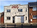
The former Sunshine Creameries, Orchardleigh Road, Shanklin
The building has since been renovated.
Image: © Paul Coueslant
Taken: 1 Apr 2016
0.05 miles
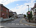
4
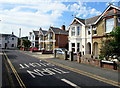
Western Road, Shanklin
Westwards from the corner of Landguard Road.
Image: © Jaggery
Taken: 22 Aug 2015
0.08 miles
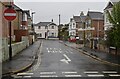
5
Eastern end of Western Road, Shanklin
From Landguard Road.
Image: © Jaggery
Taken: 22 Aug 2015
0.08 miles
7
Fernhurst Holiday Apartments, Shanklin
Facing a bend in Western Road.
Image: © Jaggery
Taken: 22 Aug 2015
0.08 miles
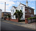
9
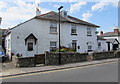
Victoria Cottage, Shanklin
Victoria Cottage is on the right side of these semi-detached houses on the west side of Landguard Road.
Image: © Jaggery
Taken: 22 Aug 2015
0.08 miles
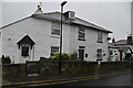
10
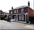
Landguard Road semis, Shanklin
Two semi-detached houses on the west side of Landguard Road.
Image: © Jaggery
Taken: 22 Aug 2015
0.08 miles