IMAGES TAKEN NEAR TO
High Street, SHANKLIN, PO37 6NL
Introduction
This page details the photographs taken nearby to High Street, PO37 6NL by members of the Geograph project.
The Geograph project started in 2005 with the aim of publishing, organising and preserving representative images for every square kilometre of Great Britain, Ireland and the Isle of Man.

There are currently over 7.5m images from over14,400 individuals and you can help contribute to the project by visiting https://www.geograph.org.uk
Image Map
Images are licensed for reuse under creativecommons.org/licenses/by-sa/2.0
Notes
- Clicking on the map will re-center to the selected point.
- The higher the marker number, the further away the image location is from the centre of the postcode.
Image Listing (398 Images Found)
Images are licensed for reuse under creativecommons.org/licenses/by-sa/2.0
Image
Details
Distance
1
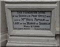
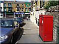
Shanklin Post Office Foundation Stone
On the High Street. Now a Londis Shop. http://www.geograph.org.uk/photo/4684251
Image: © Ian S
Taken: 19 Aug 2015
0.01 miles
2
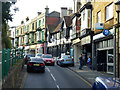
Shanklin High Street
Too narrow here for two buses to pass.
Image: © Robin Webster
Taken: 24 Sep 2016
0.01 miles
3
Victoria Avenue, Shanklin, Isle of Wight
Looking up Victoria Avenue from the High Street.
Image: © Christine Matthews
Taken: 14 Jun 2009
0.01 miles
5
Steephill Road, Shanklin, Isle of Wight
Looking towards the High Street with the theatre behind the photographer.
Image: © Christine Matthews
Taken: 14 Jun 2009
0.02 miles
7
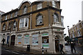
Former Shanklin Post Office
On the High Street. Now a Londis Shop. http://www.geograph.org.uk/photo/4684250
Image: © Ian S
Taken: 19 Aug 2015
0.02 miles
8
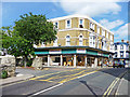
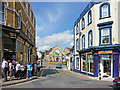
High Street, Shanklin, Isle of Wight
Looking across the High Street towards the furniture store on the corner of Pomona Road.
Image: © Christine Matthews
Taken: 14 Jun 2009
0.02 miles
9
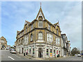
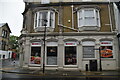
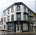
66 - 68 High Street
Former post office (marked as such on the 1908 25" map) with a date stone above the door of 1899. After closure as a post office, for a while it housed the local Job Centre. After this closed in c.2004 it remained empty for a few years before becoming a Londis supermarket in 2011 (although from c.2017-21 it was branded as a Spar).
Image: © Ian Capper
Taken: 30 Mar 2023
0.02 miles
10
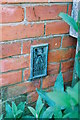
Shanklin, Victoria Avenue, Flush Bracket no, G4454
The metal bracket known as a Flush Bracket was fixed on the west face of the passageway between 2 Victoria Avenue 'Elmcroft' and neighbouring flats. It was used in the 3GL levelling of 1960 as one of the benchmarks along the Gurnard (IOW) to Freshwater (IOW) levelling line. Each FB has a unique serial number, this one being G4454. It was levelled at 56.0351 m above Newlyn datum. Details of this and neighbouring marks can be found at http:/www.bench-marks.org.uk/bm13448. A list of all the benchmarks along the levelling line can be found at http://www.bench-marks.org.uk/line281.
Image: © Roger Templeman
Taken: 17 Apr 2010
0.02 miles