IMAGES TAKEN NEAR TO
Arthurs Hill, SHANKLIN, PO37 6EW
Introduction
This page details the photographs taken nearby to Arthurs Hill, PO37 6EW by members of the Geograph project.
The Geograph project started in 2005 with the aim of publishing, organising and preserving representative images for every square kilometre of Great Britain, Ireland and the Isle of Man.

There are currently over 7.5m images from over14,400 individuals and you can help contribute to the project by visiting https://www.geograph.org.uk
Image Map
Images are licensed for reuse under creativecommons.org/licenses/by-sa/2.0
Notes
- Clicking on the map will re-center to the selected point.
- The higher the marker number, the further away the image location is from the centre of the postcode.
Image Listing (258 Images Found)
Images are licensed for reuse under creativecommons.org/licenses/by-sa/2.0
Image
Details
Distance
1
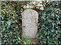
Milestone, Arthur's Hill, Shanklin
Embedded in the hedge of No. 5.
Ryde 8
Milestone Society National ID: HA_RYVN08
Image: © Daryll Pitcher
Taken: 31 Dec 2018
0.01 miles
2
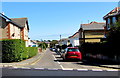
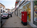
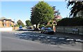
Avenue Road, Shanklin
Extending eastwards for 200 metres from Wilton Park Road on this side to the A3055 Arthurs Hill.
Image: © Jaggery
Taken: 8 Sep 2015
0.02 miles
3
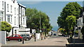
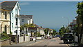
Shanklin - Atherley Road
Looking across to Hope Road, and the sea.
Image: © Peter Trimming
Taken: 2 Jun 2009
0.09 miles
4
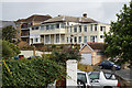
The Curraghmore Hotel on Hope Street, Shanklin
Image: © Ian S
Taken: 20 Aug 2015
0.10 miles
5
Regent Street, Shanklin, Isle of Wight
Looking down Recent Street towards the High Street.
Image: © Christine Matthews
Taken: 14 Jun 2009
0.10 miles
6
Shanklin - Atherley Road
Looking down towards the sea.
Image: © Peter Trimming
Taken: 2 Jun 2009
0.11 miles
7
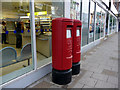
Elizabeth II Pillar Boxes, Regent Street, Shanklin, Isle of Wight
Image: © Christine Matthews
Taken: 14 Jun 2009
0.11 miles
8
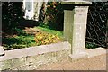
Shanklin, Crescent Road benchmark
1959 Ordnance Survey cut mark benchmark on the wall of #6 Crescent Road, on the third stone left of the gatepost (which carries the name 'Upper Hatch Flat 1') and second stone above the pavement. The mark was levelled at a height of 42.4129m above Newlyn datum. Further details of the mark and its neighbours may be found at http://www.bench-merks.org.uk/bm34077.
Image: © Roger Templeman
Taken: 17 Apr 2010
0.12 miles
9
Western end of Clarence Road, Shanklin
Viewed across Wilton Park Road.
Image: © Jaggery
Taken: 8 Sep 2015
0.12 miles
10
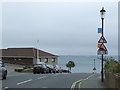
Hope Road, Shanklin
Hope Road in Shanklin, Isle of Wight. The road drops down a steep gradient to reach the sea front.
Image: © Malc McDonald
Taken: 25 Jun 2011
0.12 miles