IMAGES TAKEN NEAR TO
Cross Street, SHANKLIN, PO37 6AT
Introduction
This page details the photographs taken nearby to Cross Street, PO37 6AT by members of the Geograph project.
The Geograph project started in 2005 with the aim of publishing, organising and preserving representative images for every square kilometre of Great Britain, Ireland and the Isle of Man.

There are currently over 7.5m images from over14,400 individuals and you can help contribute to the project by visiting https://www.geograph.org.uk
Image Map
Images are licensed for reuse under creativecommons.org/licenses/by-sa/2.0
Notes
- Clicking on the map will re-center to the selected point.
- The higher the marker number, the further away the image location is from the centre of the postcode.
Image Listing (503 Images Found)
Images are licensed for reuse under creativecommons.org/licenses/by-sa/2.0
Image
Details
Distance
1
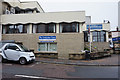
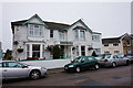
The Little John Clinic
On Cross Street, Shanklin.
Image: © Ian S
Taken: 20 Aug 2015
0.01 miles
2
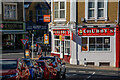
Shanklin : Cross Street
Looking towards the junction with High Street.
Image: © Lewis Clarke
Taken: 15 Oct 2020
0.01 miles
3
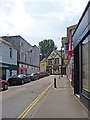
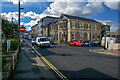
Palmerston Road, Shanklin, Isle of Wight
Looking up the hill from near junction with High Street.
Image: © Christine Matthews
Taken: 14 Jun 2009
0.01 miles
4
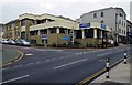
Shanklin Conservative Club, 6 Palmerston Road, Shanklin, Isle of Wight
A political club open only to people supporting the Conservative Party. All applicants are vetted and interviewed according to their website. The club was extended and altered in 2004/2005. The club offers a lot of facilities including entertainment, dance floor, dining room, bar and two snooker tables. This view shows the club's frontage to Cross Street and High Street. The older part of the building also has a frontage to Palmerston Road.
A small part of the building is used by the LittleJohn Clinic, an osteopath.
Image: © P L Chadwick
Taken: 26 Oct 2014
0.02 miles
6
Shanklin : Palmerston Road
Looking along the road.
Image: © Lewis Clarke
Taken: 15 Oct 2020
0.02 miles
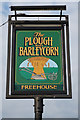
7
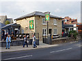
The Plough & Barleycorn
On North Road, Shanklin. http://www.geograph.org.uk/photo/4864935
Image: © Ian S
Taken: 17 Aug 2015
0.02 miles
8
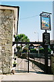
Shanklin, Plough and Barleycorn
1960 Ordnance Survey cut mark benchmark on LHS of the base corner stone on the Plough and Barleycorn pub on North Street, Shanklin. See http://www.bench-marks.org.uk/bm33992 for details.
Image: © Roger Templeman
Taken: 17 Apr 2010
0.02 miles
9
The Plough & Barleycorn
On North Road, Shanklin. http://www.geograph.org.uk/photo/4864929
Image: © Ian S
Taken: 17 Aug 2015
0.02 miles
10
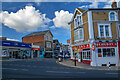
Shanklin : Regent Street
Looking off High Street.
Image: © Lewis Clarke
Taken: 15 Oct 2020
0.03 miles