IMAGES TAKEN NEAR TO
Invincible Way, PORTSMOUTH, PO3 6GW
Introduction
This page details the photographs taken nearby to Invincible Way, PO3 6GW by members of the Geograph project.
The Geograph project started in 2005 with the aim of publishing, organising and preserving representative images for every square kilometre of Great Britain, Ireland and the Isle of Man.

There are currently over 7.5m images from over14,400 individuals and you can help contribute to the project by visiting https://www.geograph.org.uk
Image Map
Images are licensed for reuse under creativecommons.org/licenses/by-sa/2.0
Notes
- Clicking on the map will re-center to the selected point.
- The higher the marker number, the further away the image location is from the centre of the postcode.
Image Listing (152 Images Found)
Images are licensed for reuse under creativecommons.org/licenses/by-sa/2.0
Image
Details
Distance
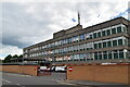
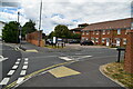
3
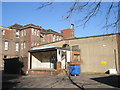
Old and the new at St Mary's
A massive hospital serving the Portsmouth region.
Image: © Basher Eyre
Taken: 17 Feb 2008
0.07 miles
5
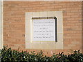
Foundation stone for new Paediatric Unit
Opened in 1993.
Image: © Basher Eyre
Taken: 17 Feb 2008
0.09 miles
7
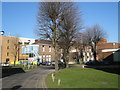
Rear of St Mary's Hospital
Taken during a lovely winter walk in February 2008.
Image: © Basher Eyre
Taken: 17 Feb 2008
0.09 miles
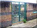
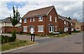
9
Loading bay at St Mary's
In constant use at this very busy concern.
Image: © Basher Eyre
Taken: 17 Feb 2008
0.10 miles