IMAGES TAKEN NEAR TO
Melville Street, SANDOWN, PO36 9DF
Introduction
This page details the photographs taken nearby to Melville Street, PO36 9DF by members of the Geograph project.
The Geograph project started in 2005 with the aim of publishing, organising and preserving representative images for every square kilometre of Great Britain, Ireland and the Isle of Man.

There are currently over 7.5m images from over14,400 individuals and you can help contribute to the project by visiting https://www.geograph.org.uk
Image Map
Images are licensed for reuse under creativecommons.org/licenses/by-sa/2.0
Notes
- Clicking on the map will re-center to the selected point.
- The higher the marker number, the further away the image location is from the centre of the postcode.
Image Listing (186 Images Found)
Images are licensed for reuse under creativecommons.org/licenses/by-sa/2.0
Image
Details
Distance
1
Sandown : Melville Street
Looking along Melvill Street.
Image: © Lewis Clarke
Taken: 15 Oct 2020
0.08 miles
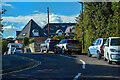
2
Sandown Council offices
Was CofE school - which moved to old Grammar School site on Grove Rd
Image: © Phil kemp
Taken: 1 Jun 2014
0.08 miles
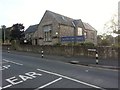
3
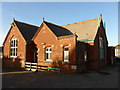
The nerve centre of Sandown Town Council
(formerly a school)
Image: © Basher Eyre
Taken: 22 Feb 2014
0.08 miles
4
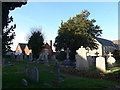
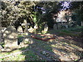
Christ Church, Sandown: churchyard (l)
Looking towards a former school which is now used as the offices for Sandown Town Council.
Image: © Basher Eyre
Taken: 22 Feb 2014
0.09 miles