IMAGES TAKEN NEAR TO
Newport Road, SANDOWN, PO36 0LS
Introduction
This page details the photographs taken nearby to Newport Road, PO36 0LS by members of the Geograph project.
The Geograph project started in 2005 with the aim of publishing, organising and preserving representative images for every square kilometre of Great Britain, Ireland and the Isle of Man.

There are currently over 7.5m images from over14,400 individuals and you can help contribute to the project by visiting https://www.geograph.org.uk
Image Map
Images are licensed for reuse under creativecommons.org/licenses/by-sa/2.0
Notes
- Clicking on the map will re-center to the selected point.
- The higher the marker number, the further away the image location is from the centre of the postcode.
Image Listing (8 Images Found)
Images are licensed for reuse under creativecommons.org/licenses/by-sa/2.0
Image
Details
Distance
2
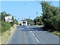
A3056 Newport Road
A3056 Newport Road at Apse Heath
Image: © Shaun Ferguson
Taken: 26 Oct 2008
0.11 miles
3
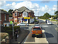
Convenience store and post office, Apse Heath
At a crossroads where route 8 buses serving the bus stop here turn right. Route 22 also goes that way, but a single journey on only four days a week.
Image: © Robin Webster
Taken: 9 Oct 2016
0.11 miles
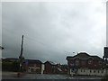
5
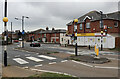
Crossroads at Apse Heath
Showing the single local store at the intersection of the A3056 Newport Road, with Alverstone Road to the north and Ventnor Road to the south.
Image: © Paul Coueslant
Taken: 15 Oct 2021
0.12 miles
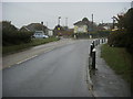
6
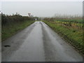
Princelett Shute
Princelett Shute nearing Branstone Cross
Image: © Shaun Ferguson
Taken: 26 Oct 2008
0.23 miles
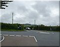
8

Newchurch : Winford Road
A road off the A3056.
Image: © Lewis Clarke
Taken: 15 Oct 2020
0.25 miles