IMAGES TAKEN NEAR TO
Howgate Road, BEMBRIDGE, PO35 5TQ
Introduction
This page details the photographs taken nearby to Howgate Road, PO35 5TQ by members of the Geograph project.
The Geograph project started in 2005 with the aim of publishing, organising and preserving representative images for every square kilometre of Great Britain, Ireland and the Isle of Man.

There are currently over 7.5m images from over14,400 individuals and you can help contribute to the project by visiting https://www.geograph.org.uk
Image Map
Images are licensed for reuse under creativecommons.org/licenses/by-sa/2.0
Notes
- Clicking on the map will re-center to the selected point.
- The higher the marker number, the further away the image location is from the centre of the postcode.
Image Listing (122 Images Found)
Images are licensed for reuse under creativecommons.org/licenses/by-sa/2.0
Image
Details
Distance
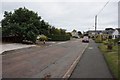
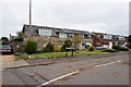
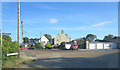
2
Howgate Road
Houses in Howgate Road, originally a lane marked on old maps as connecting Howgate Farm and Foreland Farm, but with no substantial development until the mid 20th Century.
Image: © Ian Capper
Taken: 31 Mar 2023
0.02 miles
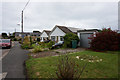
3
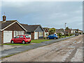
Beachfield Road
c.1960s bungalows in a cul-de-sac off Howgate Road.
Image: © Ian Capper
Taken: 31 Mar 2023
0.02 miles
4
Sandpipers
Cul-de-sac off Howgate Road built 2001-4.
Image: © Ian Capper
Taken: 31 Mar 2023
0.03 miles
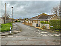
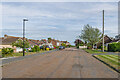
7
Paddock Drive
Cul-de-sac off Howgate Road developed in the c.1960s/70s.
Image: © Ian Capper
Taken: 31 Mar 2023
0.04 miles
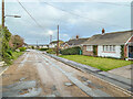
8
Beachfield Road
c.1960s bungalows in a cul-de-sac off Lane End Road.
Image: © Ian Capper
Taken: 10 May 2022
0.05 miles
9
Foreland Farm Lane junction with Poplar Close
Image: © Stuart Logan
Taken: 13 Aug 2014
0.06 miles
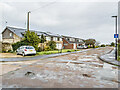
10
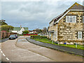
Howgate Road
Looking along Howgate Road to where it meets Foreland Farm Lane. The buildings on the right are converted outbuildings of the former Foreland Farm. The green roofed building in the background is Hollywood House, part of the Warner Hotels Bembridge Coast complex.
Image: © Ian Capper
Taken: 31 Mar 2023
0.06 miles