IMAGES TAKEN NEAR TO
Lushington Hill, RYDE, PO33 4RD
Introduction
This page details the photographs taken nearby to Lushington Hill, PO33 4RD by members of the Geograph project.
The Geograph project started in 2005 with the aim of publishing, organising and preserving representative images for every square kilometre of Great Britain, Ireland and the Isle of Man.

There are currently over 7.5m images from over14,400 individuals and you can help contribute to the project by visiting https://www.geograph.org.uk
Image Map
Images are licensed for reuse under creativecommons.org/licenses/by-sa/2.0
Notes
- Clicking on the map will re-center to the selected point.
- The higher the marker number, the further away the image location is from the centre of the postcode.
Image Listing (16 Images Found)
Images are licensed for reuse under creativecommons.org/licenses/by-sa/2.0
Image
Details
Distance
1
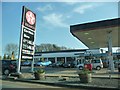
Wootton : Texaco Petrol Station
Unleaded now approaching the £1.50 mark at this petrol station on High Street.
Image: © Lewis Clarke
Taken: 2 Apr 2012
0.01 miles
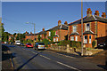
3
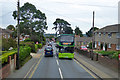
Route 4 bus, High Street, Wootton
Heading for East Cowes from Ryde. Route 4 is one of the few Southern Vectis routes that does not touch Newport.
Image: © Robin Webster
Taken: 24 Sep 2016
0.10 miles
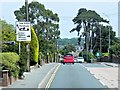
4
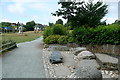
Park at Wootton Bridge
This is a popular local park, with a children's play area and interesting artistic designs of stone, as well as a large area of grass and a few paths.
Image: © Graham Horn
Taken: 11 Jul 2010
0.11 miles
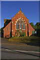
5
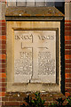
St Mark, Wootton
The dedication stone http://www.geograph.org.uk/photo/1419195 was laid by James Macarthur https://en.wikipedia.org/wiki/James_Macarthur
Image: © Basher Eyre
Taken: 22 Feb 2014
0.12 miles
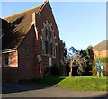
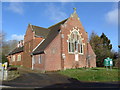
7
St Mark's Church
Built in 1909 (for dedication stone see Image). Following damage in the second world war, the building fell into for a number of years it was rededicated in 1970.
Information from church website at http://www.woottonparish.co.uk/stmarks.php
Image: © Ian Capper
Taken: 12 Jul 2009
0.13 miles
9
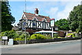
The Cedars
A pub at Wootton Bridge at the junction of the A3054 Ryde to Newport road via Fairlee and the minor road route via Staplers.
Image: © Graham Horn
Taken: 11 Jul 2010
0.13 miles