IMAGES TAKEN NEAR TO
Station Road, RYDE, PO33 4DT
Introduction
This page details the photographs taken nearby to Station Road, PO33 4DT by members of the Geograph project.
The Geograph project started in 2005 with the aim of publishing, organising and preserving representative images for every square kilometre of Great Britain, Ireland and the Isle of Man.

There are currently over 7.5m images from over14,400 individuals and you can help contribute to the project by visiting https://www.geograph.org.uk
Image Map
Images are licensed for reuse under creativecommons.org/licenses/by-sa/2.0
Notes
- Clicking on the map will re-center to the selected point.
- The higher the marker number, the further away the image location is from the centre of the postcode.
Image Listing (113 Images Found)
Images are licensed for reuse under creativecommons.org/licenses/by-sa/2.0
Image
Details
Distance
1
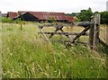
Barn at Guildford Farm
Another farm building that has seen better days, with a very overgrown meadow.
Image: © Graham Horn
Taken: 16 Jun 2007
0.03 miles
2
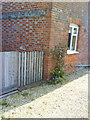
Havenstreet, Guildford Farmhouse
There is a large Ordnance Survey cut mark benchmark on the 5th and 6th brick courses above the drive, about 6 inches from the angle of the farmhouse. The mark is at 18.7970m above Newlyn datum, and was verified in 1960. More information on this and other nearby benchmarks may be found in the Bench Mark Database at http://www.bench-marks.org.uk/bm34055.
Image: © Roger Templeman
Taken: 18 Apr 2010
0.05 miles
3

Havenstreet, Blackbridge Brook culvert
Ordnance Survey rivet benchmark on concrete top of culvert for Blackbridge Brook. The mark takes the form of a rivet at the tip of the familiar arrow cuts. The mark was levelled at 13.1491m above Newlyn datum and verified in 1960. Additional information on this and other nearby benchmarks may be found in the Bench Mark Database at http://www.bench-marks.org.uk/bm34056.
Image: © Roger Templeman
Taken: 18 Apr 2010
0.12 miles
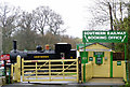
4
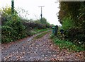
Access road to Havencroft Farm, Havenstreet
Image: © nick macneill
Taken: 16 Nov 2012
0.13 miles
5
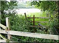
Stiles near Guildford Farm
This footpath was quite challenge to find across a damp over-grown meadow.
Image: © Graham Horn
Taken: 16 Jun 2007
0.16 miles
6
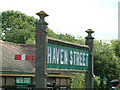
Sign at Havenstreet Station
On the Isle of Wight Steam Railway
Image: © Stephen Dawson
Taken: 7 Jun 2003
0.17 miles
7
Havenstreet Station
Isle of Wight Steam Railway
Image: © David Ballard
Taken: 1 Apr 2003
0.17 miles
8
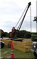
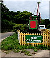
Old railway crane, Havenstreet
In the Isle of Wight Steam Railway free car park,
about 100 metres from the entrance to Havenstreet railway station.
http://www.geograph.org.uk/photo/4761705 to another view.
Image: © Jaggery
Taken: 4 Sep 2015
0.18 miles
9
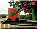
Old railway crane detail, Havenstreet
The inscription on this http://www.geograph.org.uk/photo/4761696 old crane shows that it was made by James Taylor & Co, Engineers, Birkenhead.
Image: © Jaggery
Taken: 4 Sep 2015
0.18 miles
10
Back of an old railway crane, Havenstreet
In the Isle of Wight Steam Railway free car park,
about 100 metres from the entrance to Havenstreet railway station.
http://www.geograph.org.uk/photo/4761696 to another view.
Image: © Jaggery
Taken: 4 Sep 2015
0.18 miles