IMAGES TAKEN NEAR TO
Harding Shute, RYDE, PO33 4AP
Introduction
This page details the photographs taken nearby to Harding Shute, PO33 4AP by members of the Geograph project.
The Geograph project started in 2005 with the aim of publishing, organising and preserving representative images for every square kilometre of Great Britain, Ireland and the Isle of Man.

There are currently over 7.5m images from over14,400 individuals and you can help contribute to the project by visiting https://www.geograph.org.uk
Image Map
Images are licensed for reuse under creativecommons.org/licenses/by-sa/2.0
Notes
- Clicking on the map will re-center to the selected point.
- The higher the marker number, the further away the image location is from the centre of the postcode.
Image Listing (6 Images Found)
Images are licensed for reuse under creativecommons.org/licenses/by-sa/2.0
Image
Details
Distance
1
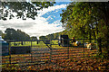
Brading : Grassy Field
A grassy field beyond the gate.
Image: © Lewis Clarke
Taken: 15 Oct 2020
0.04 miles
2
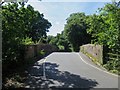
Bridge over the Ryde to Shanklin railway at Harding Shute
Image: © Paul Coueslant
Taken: 13 Aug 2017
0.05 miles
3
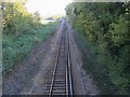
The Wight Line
Looking down from the bridge on Harding Shute to the Wight Line.
Image: © Shaun Ferguson
Taken: 31 Oct 2008
0.12 miles
4

Roke Mead Copse
Public Footpath B18 heading around the field to Roke Mead Copse.
Image: © Shaun Ferguson
Taken: 31 Oct 2008
0.16 miles
5

Brading : Harding Shute
Looking along the road.
Image: © Lewis Clarke
Taken: 15 Oct 2020
0.20 miles
6
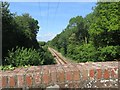
Bridge crossing the Shanklin to Ryde railway at Harding Shute
Image: © Paul Coueslant
Taken: 13 Aug 2017
0.20 miles