IMAGES TAKEN NEAR TO
Newnham Road, RYDE, PO33 3TE
Introduction
This page details the photographs taken nearby to Newnham Road, PO33 3TE by members of the Geograph project.
The Geograph project started in 2005 with the aim of publishing, organising and preserving representative images for every square kilometre of Great Britain, Ireland and the Isle of Man.

There are currently over 7.5m images from over14,400 individuals and you can help contribute to the project by visiting https://www.geograph.org.uk
Image Map
Images are licensed for reuse under creativecommons.org/licenses/by-sa/2.0
Notes
- Clicking on the map will re-center to the selected point.
- The higher the marker number, the further away the image location is from the centre of the postcode.
Image Listing (28 Images Found)
Images are licensed for reuse under creativecommons.org/licenses/by-sa/2.0
Image
Details
Distance
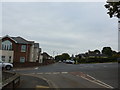
1
Looking west-northwest along Arnold Road
Image: © Basher Eyre
Taken: 17 Oct 2015
0.16 miles
2
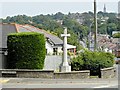
Junction of Church Road, Quarr Hill, Binstead Hill and Newnham Road
Image: © Basher Eyre
Taken: 17 Oct 2015
0.17 miles
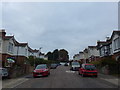
3

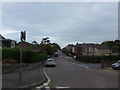
Parkway, Binstead looking north
A typical residential street in this suburb of Ryde.
Image: © Paul Coueslant
Taken: 17 Mar 2020
0.17 miles
4
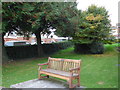
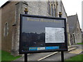
Binstead Methodist Church: seat in the churchyard
Image: © Basher Eyre
Taken: 17 Oct 2015
0.17 miles
5
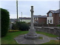
War memorial at the junction of Church Road and Binstead Hill
Image: © Basher Eyre
Taken: 17 Oct 2015
0.18 miles
7
Junction of Arnold Road and Chapel Road, looking towards Sandpath
Image: © Basher Eyre
Taken: 17 Oct 2015
0.18 miles
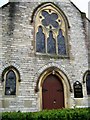
8
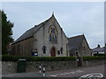
Binstead Methodist Church: mid October 2015
Image: © Basher Eyre
Taken: 17 Oct 2015
0.18 miles