IMAGES TAKEN NEAR TO
Wykeham Close, RYDE, PO33 3ST
Introduction
This page details the photographs taken nearby to Wykeham Close, PO33 3ST by members of the Geograph project.
The Geograph project started in 2005 with the aim of publishing, organising and preserving representative images for every square kilometre of Great Britain, Ireland and the Isle of Man.

There are currently over 7.5m images from over14,400 individuals and you can help contribute to the project by visiting https://www.geograph.org.uk
Image Map
Images are licensed for reuse under creativecommons.org/licenses/by-sa/2.0
Notes
- Clicking on the map will re-center to the selected point.
- The higher the marker number, the further away the image location is from the centre of the postcode.
Image Listing (64 Images Found)
Images are licensed for reuse under creativecommons.org/licenses/by-sa/2.0
Image
Details
Distance
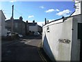
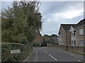
2
Junction of Wykeham Close and Pitts Lane
Image: © Basher Eyre
Taken: 17 Oct 2015
0.06 miles
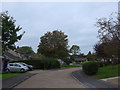
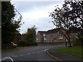
3
Approaching the junction of Pitts Lane and Old Forge Close
Image: © Basher Eyre
Taken: 17 Oct 2015
0.06 miles
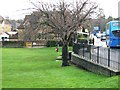
5
Looking from Wykeham Close, across to Old Forge Close
Image: © Basher Eyre
Taken: 17 Oct 2015
0.07 miles
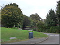
7
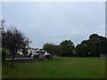
Binstead Recreation Ground: October 2015
Image: © Basher Eyre
Taken: 17 Oct 2015
0.08 miles
8

D-Day exhibition at Holy Cross, Binstead (xiii)
Image: © Basher Eyre
Taken: 7 Jun 2014
0.09 miles
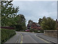
9

A3054 descending Binstead Hill beyond junction with Arnold Road
Image: © Stuart Logan
Taken: 12 Aug 2014
0.09 miles