IMAGES TAKEN NEAR TO
Grenville Drive, RYDE, PO33 3JW
Introduction
This page details the photographs taken nearby to Grenville Drive, PO33 3JW by members of the Geograph project.
The Geograph project started in 2005 with the aim of publishing, organising and preserving representative images for every square kilometre of Great Britain, Ireland and the Isle of Man.

There are currently over 7.5m images from over14,400 individuals and you can help contribute to the project by visiting https://www.geograph.org.uk
Image Map
Images are licensed for reuse under creativecommons.org/licenses/by-sa/2.0
Notes
- Clicking on the map will re-center to the selected point.
- The higher the marker number, the further away the image location is from the centre of the postcode.
Image Listing (83 Images Found)
Images are licensed for reuse under creativecommons.org/licenses/by-sa/2.0
Image
Details
Distance
1
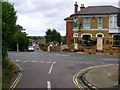
Lake Huron Pub, Haylands
On the junction of Upton Road and Bettesworth Road in the Haylands district of Ryde. The name comes from the Lake family a 19th century family of brewers who owned a couple of pubs and named them after the great lakes, the Lake Huron survives but the Lake Superior in Elmfield has gone. A locals pub rather than one for tourists.
Image: © Simon Carey
Taken: 19 Aug 2007
0.11 miles
3
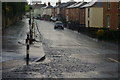
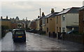
Upton Road, Haylands, Isle of Wight
Seen during a thunder storm, with torrential rain turning to hail. Looking up Upton Road, from the junction with Colenutt's Road.
With sodden trousers clinging to my legs, and doing my best John Wayne impression, I trudged up the hill. At the top of the hill, and with hail accumulating on the road and pavement, I found an elderly lady, and a motorcyclist (in leathers), sheltering where there was no shelter. I trudged on ...
Image: © Peter Trimming
Taken: 12 Apr 2012
0.13 miles
4
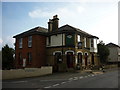
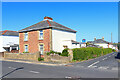
Upton Road, Haylands
On the outskirts of Ryde heading into town.
Image: © Simon Carey
Taken: 19 Aug 2007
0.14 miles
5
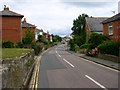
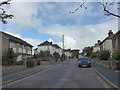
Upton Road, Haylands, Isle of Wight
Looking towards Ryde, as torrential rain fell, during a thunder storm. The thunder set off several car alarms.
Image: © Peter Trimming
Taken: 12 Apr 2012
0.15 miles
7
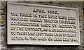
War Memorial plaque, St Michael's Avenue, Swanmore, Ryde
The plaque dated April 1950 is on the wall of St Michael's church hall. http://www.geograph.org.uk/photo/4700963
It records that the trees in this area were provided mainly by voluntary contributions made by residents of the district as a living memorial to those who lost their lives by enemy action in the area on June 22nd 1941.
The Isle of Wight Memorials website shows the names of the 12 people who were killed during the air raid on the area in 1941. They were all residents of Church Road (now named St Michael's Avenue).
Image: © Jaggery
Taken: 10 Oct 2015
0.17 miles
8
Looking south-southeast along St Michael's Avenue
Image: © Basher Eyre
Taken: 12 Sep 2015
0.17 miles
9
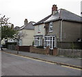
St Michael's Avenue semis, Swanmore, Ryde
Semi-detached houses opposite St Michael & All Angels church and church hall.
Image: © Jaggery
Taken: 10 Oct 2015
0.17 miles
10
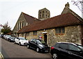
St Michael's church hall, Swanmore, Ryde
The St Michael's Avenue hall is on the southwest side of the Parish Church of St Michael & All Angels. http://www.geograph.org.uk/photo/4700896
The church tower is in the background, on the Wray Street side.
Image: © Jaggery
Taken: 10 Oct 2015
0.18 miles