1
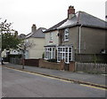
St Michael's Avenue semis, Swanmore, Ryde
Semi-detached houses opposite St Michael & All Angels church and church hall.
Image: © Jaggery
Taken: 10 Oct 2015
0.10 miles
2
War Memorial plaque, St Michael's Avenue, Swanmore, Ryde
The plaque dated April 1950 is on the wall of St Michael's church hall. http://www.geograph.org.uk/photo/4700963
It records that the trees in this area were provided mainly by voluntary contributions made by residents of the district as a living memorial to those who lost their lives by enemy action in the area on June 22nd 1941.
The Isle of Wight Memorials website shows the names of the 12 people who were killed during the air raid on the area in 1941. They were all residents of Church Road (now named St Michael's Avenue).
Image: © Jaggery
Taken: 10 Oct 2015
0.10 miles
3
Looking south-southeast along St Michael's Avenue
Image: © Basher Eyre
Taken: 12 Sep 2015
0.10 miles
4
St Michael's church hall, Swanmore, Ryde
The St Michael's Avenue hall is on the southwest side of the Parish Church of St Michael & All Angels. http://www.geograph.org.uk/photo/4700896
The church tower is in the background, on the Wray Street side.
Image: © Jaggery
Taken: 10 Oct 2015
0.10 miles
5
Victorian church foundation stone, Swanmore, Ryde
In the wall on the St Michael's Avenue side of the Parish Church of St Michael & All Angels http://www.geograph.org.uk/photo/4700896
The inscription records that the stone was laid at Easter MDCCCLXI (1861).
Image: © Jaggery
Taken: 10 Oct 2015
0.11 miles
6
St Michael & All Angels, Swanmore
Image: © John Salmon
Taken: 9 Aug 1999
0.11 miles
7
St Michael and All Angels, Swanmore: stained glass window (vii)
Image: © Basher Eyre
Taken: 12 Sep 2015
0.12 miles
8
St Michael and All Angels, Swanmore: stained glass window (i)
Image: © Basher Eyre
Taken: 12 Sep 2015
0.12 miles
9
St Michael and All Angels, Swanmore: stained glass window (ii)
Image: © Basher Eyre
Taken: 12 Sep 2015
0.12 miles
10
St Michael and All Angels, Swanmore: stained glass window (iii)
Image: © Basher Eyre
Taken: 12 Sep 2015
0.12 miles


