IMAGES TAKEN NEAR TO
Lower Bettesworth Road, RYDE, PO33 3EQ
Introduction
This page details the photographs taken nearby to Lower Bettesworth Road, PO33 3EQ by members of the Geograph project.
The Geograph project started in 2005 with the aim of publishing, organising and preserving representative images for every square kilometre of Great Britain, Ireland and the Isle of Man.

There are currently over 7.5m images from over14,400 individuals and you can help contribute to the project by visiting https://www.geograph.org.uk
Image Map
Images are licensed for reuse under creativecommons.org/licenses/by-sa/2.0
Notes
- Clicking on the map will re-center to the selected point.
- The higher the marker number, the further away the image location is from the centre of the postcode.
Image Listing (95 Images Found)
Images are licensed for reuse under creativecommons.org/licenses/by-sa/2.0
Image
Details
Distance
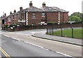
1
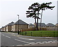
V-shaped tree, Bettesworth Road, Ryde
Viewed across Ashey Road in October 2015 looking towards recently-built (c2014) houses in Ashey Place.
Image: © Jaggery
Taken: 10 Oct 2015
0.13 miles
2
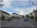
Looking south-southeast along St Michael's Avenue
Image: © Basher Eyre
Taken: 12 Sep 2015
0.13 miles
3
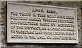
War Memorial plaque, St Michael's Avenue, Swanmore, Ryde
The plaque dated April 1950 is on the wall of St Michael's church hall. http://www.geograph.org.uk/photo/4700963
It records that the trees in this area were provided mainly by voluntary contributions made by residents of the district as a living memorial to those who lost their lives by enemy action in the area on June 22nd 1941.
The Isle of Wight Memorials website shows the names of the 12 people who were killed during the air raid on the area in 1941. They were all residents of Church Road (now named St Michael's Avenue).
Image: © Jaggery
Taken: 10 Oct 2015
0.13 miles
4
West side of Ashey Road, Ryde
Viewed from the corner of Rosemary Lane. The houses on the right face the Woodland View junction.
Image: © Jaggery
Taken: 10 Oct 2015
0.13 miles
5
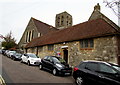
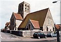
St Michael's church hall, Swanmore, Ryde
The St Michael's Avenue hall is on the southwest side of the Parish Church of St Michael & All Angels. http://www.geograph.org.uk/photo/4700896
The church tower is in the background, on the Wray Street side.
Image: © Jaggery
Taken: 10 Oct 2015
0.13 miles
6
Corner of Ashey Road and Bettesworth Road, Ryde
Viewed across Ashey Road.
Image: © Jaggery
Taken: 10 Oct 2015
0.13 miles
7
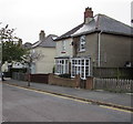
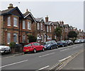
St Michael's Avenue semis, Swanmore, Ryde
Semi-detached houses opposite St Michael & All Angels church and church hall.
Image: © Jaggery
Taken: 10 Oct 2015
0.13 miles
8
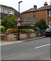
Warning signs, Ashey Road, Swanmore
Red-edged triangular signs on a lamppost warn of traffic lights and a narrowing of the road ahead.
Image: © Jaggery
Taken: 10 Oct 2015
0.14 miles
10
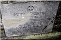
Victorian church foundation stone, Swanmore, Ryde
In the wall on the St Michael's Avenue side of the Parish Church of St Michael & All Angels http://www.geograph.org.uk/photo/4700896
The inscription records that the stone was laid at Easter MDCCCLXI (1861).
Image: © Jaggery
Taken: 10 Oct 2015
0.14 miles