1
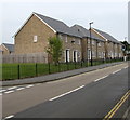
Recently-built houses, Ashey Place, Ryde
The Ashey Road side of Ashey Place houses built c2014, viewed in October 2015.
Image: © Jaggery
Taken: 10 Oct 2015
0.03 miles
2
Ashey Road houses, Ryde
Row of houses between Ashey Close and Ashey Place.
Image: © Jaggery
Taken: 10 Oct 2015
0.03 miles
3
V-shaped tree, Bettesworth Road, Ryde
Viewed across Ashey Road in October 2015 looking towards recently-built (c2014) houses in Ashey Place.
Image: © Jaggery
Taken: 10 Oct 2015
0.04 miles
4
Ashey Close, Ryde
Cul-de-sac on the west side of Ashey Road.
The tower of St Michael & All Angels church http://www.geograph.org.uk/photo/4700896 is in the background.
Image: © Jaggery
Taken: 10 Oct 2015
0.04 miles
5
Pelican crossing, Ashey Road, Ryde
A pelican crossing is the type of pedestrian-operated street crossing seen here.
Chambers Dictionary states that "pelican" is adapted from "pedestrian light controlled crossing".
Image: © Jaggery
Taken: 10 Oct 2015
0.04 miles
6
St Michael's church hall, Swanmore, Ryde
The St Michael's Avenue hall is on the southwest side of the Parish Church of St Michael & All Angels. http://www.geograph.org.uk/photo/4700896
The church tower is in the background, on the Wray Street side.
Image: © Jaggery
Taken: 10 Oct 2015
0.05 miles
7
Victorian vicarage, Wray Street, Ryde
This building is connected to St Michael & All Angels church http://www.geograph.org.uk/photo/4700896 behind the camera.
It was built at the same time as the church, in the early 1860s.
The vicarage was Grade II listed in 1972.
Image: © Jaggery
Taken: 10 Oct 2015
0.06 miles
8
St Michael & All Angels, Swanmore, Ryde
On the corner of Wray Street and St Michael's Avenue. The Parish Church of St Michael & All Angels Swanmore is part of the Church of England Diocese of Portsmouth. The building's foundation stone http://www.geograph.org.uk/photo/4700972 was laid at Easter 1861.
Grade II* listed in 1972.
Image: © Jaggery
Taken: 10 Oct 2015
0.06 miles
9
St Michael & All Angels, Swanmore
Image: © John Salmon
Taken: 9 Aug 1999
0.06 miles
10
Grade II listed vicarage, Wray Street, Ryde
The building is connected to St Michael & All Angels church http://www.geograph.org.uk/photo/4700896 in the background.
The vicarage and church were built in the early 1860s. The vicarage was Grade II listed in 1972.
Image: © Jaggery
Taken: 10 Oct 2015
0.06 miles


