IMAGES TAKEN NEAR TO
Nelson Place, RYDE, PO33 2ET
Introduction
This page details the photographs taken nearby to Nelson Place, PO33 2ET by members of the Geograph project.
The Geograph project started in 2005 with the aim of publishing, organising and preserving representative images for every square kilometre of Great Britain, Ireland and the Isle of Man.

There are currently over 7.5m images from over14,400 individuals and you can help contribute to the project by visiting https://www.geograph.org.uk
Image Map
Images are licensed for reuse under creativecommons.org/licenses/by-sa/2.0
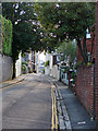
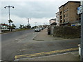
Notes
- Clicking on the map will re-center to the selected point.
- The higher the marker number, the further away the image location is from the centre of the postcode.
Image Listing (672 Images Found)
Images are licensed for reuse under creativecommons.org/licenses/by-sa/2.0
Image
Details
Distance
1
Bellevue Road, Ryde
Looking westwards from Dover Street.
Image: © John Lucas
Taken: 4 Jun 2008
0.03 miles
2
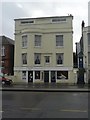
Ryde: The Happy Heifer
A café, closed on this showery Tuesday out of season, with a peculiar big hand in the window of the former shop next door.
Image: © Chris Downer
Taken: 5 Feb 2008
0.04 miles
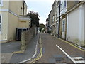
3
Junction of Nelson Street and Bellevue Road
Image: © Basher Eyre
Taken: 17 Oct 2015
0.05 miles
4
Looking from Nelson Street into Bellevue Road
Image: © Basher Eyre
Taken: 17 Oct 2015
0.05 miles
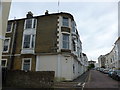
5
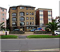
Vokins Rise, Ryde
5-storey block of flats viewed across the A3055 Esplanade.
Image: © Jaggery
Taken: 4 Sep 2015
0.05 miles
6
Ryde Castle Hotel
Situated on the corner of the Esplanade and Dover Street, the hotel has views over Spithead.
Image: © Peter Jordan
Taken: 15 May 2006
0.05 miles
7
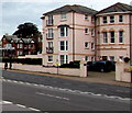
Pink building, Esplanade, Ryde
Solent Court flats viewed across the A3055 Esplanade.
Image: © Jaggery
Taken: 4 Sep 2015
0.06 miles
8
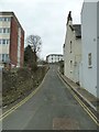
Looking from Ryde Esplanade into Nelson Place
Image: © Basher Eyre
Taken: 30 Mar 2013
0.06 miles
9
Junction of Ryde Esplanade and Nelson Place
Image: © Basher Eyre
Taken: 30 Mar 2013
0.06 miles
10
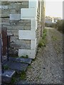
Ryde, 23 Nelson Street
Large 1960 Ordnance Survey cut mark benchmark on #23 Nelson Street which may be a converted chapel. The mark was levelled at 18.7086m above Newlyn datum. More details of this mark and others nearby may be found at http://www.bench-marks.org.uk/bm34004.
Image: © Roger Templeman
Taken: 17 Apr 2010
0.06 miles