IMAGES TAKEN NEAR TO
Slade Road, RYDE, PO33 1HZ
Introduction
This page details the photographs taken nearby to Slade Road, PO33 1HZ by members of the Geograph project.
The Geograph project started in 2005 with the aim of publishing, organising and preserving representative images for every square kilometre of Great Britain, Ireland and the Isle of Man.

There are currently over 7.5m images from over14,400 individuals and you can help contribute to the project by visiting https://www.geograph.org.uk
Image Map
Images are licensed for reuse under creativecommons.org/licenses/by-sa/2.0
Notes
- Clicking on the map will re-center to the selected point.
- The higher the marker number, the further away the image location is from the centre of the postcode.
Image Listing (104 Images Found)
Images are licensed for reuse under creativecommons.org/licenses/by-sa/2.0
Image
Details
Distance
1
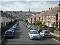
View down Harding Road, Oakfield, Ryde
View from a route 2 bus waiting for a clear run down the hill. A police car flashing blue has just turned into the road at the bottom.
Image: © Robin Webster
Taken: 19 Aug 2017
0.08 miles
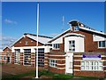
3
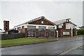
Ryde fire station
Ryde fire station, Nicholson Road, Ryde, Isle Of Wight
Image: © Kevin Hale
Taken: 18 May 2009
0.12 miles
4
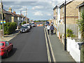
High Street, Oakfield, Ryde
From a bus on route 2 heading for Ryde bus station.
Image: © Robin Webster
Taken: 19 Aug 2017
0.14 miles
5
Island Line semaphore signal, Ryde
The signal is on the Island Line railway between Ryde St John's Road station
and Smallbrook Junction station. Viewed from the southern end of Quarry Road.
Image: © Jaggery
Taken: 10 Oct 2015
0.14 miles
7
Great Preston Road, Ryde
From a bus on route 2 heading for Ryde bus station.
Image: © Robin Webster
Taken: 19 Aug 2017
0.15 miles
8
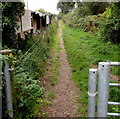
South along Public Footpath R103 towards Smallbrook from Ryde
Viewed from this gate http://www.geograph.org.uk/photo/4696579 at the southern end of Quarry Road, Ryde.
Image: © Jaggery
Taken: 10 Oct 2015
0.16 miles
9
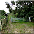
Track beyond the southern end of Quarry Road, Ryde
A sign behind the camera shows that this track is part of Public Footpath R103 to Smallbrook.
Image: © Jaggery
Taken: 10 Oct 2015
0.16 miles
10
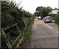
Towards the southern end of Quarry Road, Ryde
South of the Alfred Street junction, http://www.geograph.org.uk/photo/4696194 Quarry Road ends at the edge of a track behind the cars.
A nearby sign shows that the track is part of Public Footpath R103 to Smallbrook.
Image: © Jaggery
Taken: 10 Oct 2015
0.16 miles