IMAGES TAKEN NEAR TO
Gassiot Green Road, RYDE, PO33 1FQ
Introduction
This page details the photographs taken nearby to Gassiot Green Road, PO33 1FQ by members of the Geograph project.
The Geograph project started in 2005 with the aim of publishing, organising and preserving representative images for every square kilometre of Great Britain, Ireland and the Isle of Man.

There are currently over 7.5m images from over14,400 individuals and you can help contribute to the project by visiting https://www.geograph.org.uk
Image Map
Images are licensed for reuse under creativecommons.org/licenses/by-sa/2.0
Notes
- Clicking on the map will re-center to the selected point.
- The higher the marker number, the further away the image location is from the centre of the postcode.
Image Listing (119 Images Found)
Images are licensed for reuse under creativecommons.org/licenses/by-sa/2.0
Image
Details
Distance
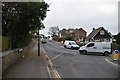
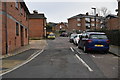
4
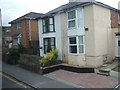
Contrasting semi-detached houses in Ryde
These houses are in St John's Hill, B3330
Image: © David Smith
Taken: 27 Sep 2010
0.09 miles
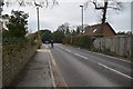
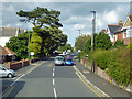
5
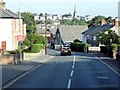
Lower Highland Road
The name is interesting; Upper Highland Road forks off it after a short distance.
Image: © David Smith
Taken: 27 Sep 2010
0.10 miles
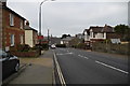
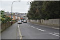
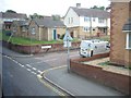
8
Great Preston Road, Ryde
Viewed from a route 2 bus swinging out to make the turn into Harding Road on the left. It is remarkable how standard sized large buses take the most unlikely routes on the Isle of Wight.
Image: © Robin Webster
Taken: 19 Aug 2017
0.12 miles