IMAGES TAKEN NEAR TO
Church Path, EAST COWES, PO32 6RL
Introduction
This page details the photographs taken nearby to Church Path, PO32 6RL by members of the Geograph project.
The Geograph project started in 2005 with the aim of publishing, organising and preserving representative images for every square kilometre of Great Britain, Ireland and the Isle of Man.

There are currently over 7.5m images from over14,400 individuals and you can help contribute to the project by visiting https://www.geograph.org.uk
Image Map
Images are licensed for reuse under creativecommons.org/licenses/by-sa/2.0
Notes
- Clicking on the map will re-center to the selected point.
- The higher the marker number, the further away the image location is from the centre of the postcode.
Image Listing (238 Images Found)
Images are licensed for reuse under creativecommons.org/licenses/by-sa/2.0
Image
Details
Distance
1
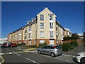
Church Path, East Cowes
Recently-built apartments on Church Path in East Cowes.
Image: © Malc McDonald
Taken: 14 Oct 2020
0.01 miles
3
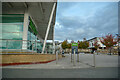
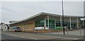
East Cowes : Waitrose
Waitrose in East Cowes.
Image: © Lewis Clarke
Taken: 14 Oct 2020
0.07 miles
4
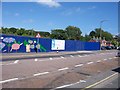
Building Site - East Cowes
Large fence surrounding a Building site in East Cowes. The sign says Project East Cowes. A mixed development, I think.
Image: © Colin Babb
Taken: 23 Jun 2008
0.08 miles
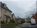
6
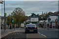
East Cowes : Well Road
Looking along Well Road.
Image: © Lewis Clarke
Taken: 14 Oct 2020
0.08 miles
7
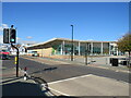
Well Road, East Cowes
Well Road in East Cowes, on the Isle of Wight.
On the opposite side of the road is a recently-built Waitrose supermarket.
Image: © Malc McDonald
Taken: 11 Oct 2020
0.09 miles
8
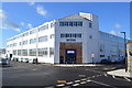
Columbine Building - Venture Quays
Former seaplane and hovercraft factory built in 1935.
Image: © John M
Taken: 21 Feb 2015
0.09 miles
9
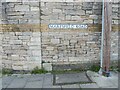
Old Boundary Marker on Maresfield Road, East Cowes
War Department Boundary Marker on Maresfield Road on the southeast corner of the boundary wall of the former Victoria barracks. East Cowes parish. The inscription has been removed.
Milestone Society National ID: IW_WDECOW04em
Image: © D Pitcher
Taken: 20 Mar 2022
0.10 miles
10
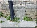
Old Boundary Marker on Columbine Road, East Cowes
War Department Boundary Marker on Columbine Road on the southeast corner of the boundary wall of the former Victoria barracks. East Cowes parish. The inscription has been removed.
Milestone Society National ID: IW_WDECOW03em
Image: © D Pitcher
Taken: 20 Mar 2022
0.10 miles