IMAGES TAKEN NEAR TO
Horseshoe Close, COWES, PO31 8PZ
Introduction
This page details the photographs taken nearby to Horseshoe Close, PO31 8PZ by members of the Geograph project.
The Geograph project started in 2005 with the aim of publishing, organising and preserving representative images for every square kilometre of Great Britain, Ireland and the Isle of Man.

There are currently over 7.5m images from over14,400 individuals and you can help contribute to the project by visiting https://www.geograph.org.uk
Image Map
Images are licensed for reuse under creativecommons.org/licenses/by-sa/2.0
Notes
- Clicking on the map will re-center to the selected point.
- The higher the marker number, the further away the image location is from the centre of the postcode.
Image Listing (5 Images Found)
Images are licensed for reuse under creativecommons.org/licenses/by-sa/2.0
Image
Details
Distance
1
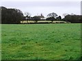
Furzyhurst
Looking up from Pallance Farm across Furzyhurst towards Northwood
Image: © Mark Pilbeam
Taken: 3 Jan 2006
0.18 miles
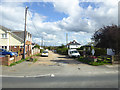
2
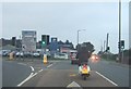
Fork in the Road
On the road to Cowes
Image: © Martyn Davies
Taken: 14 Oct 2006
0.19 miles
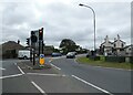
4
Northwood Stores
In Newport Road, handy for the bus stops.
Image: © Robin Webster
Taken: 9 Oct 2016
0.22 miles
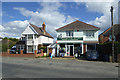
5
Coronation Avenue
An unmade road. Looking at old maps, the coronation referred to was probably that of George VI, certainly not Elizabeth II.
Image: © Robin Webster
Taken: 9 Oct 2016
0.24 miles