IMAGES TAKEN NEAR TO
Pallance Road, COWES, PO31 8LN
Introduction
This page details the photographs taken nearby to Pallance Road, PO31 8LN by members of the Geograph project.
The Geograph project started in 2005 with the aim of publishing, organising and preserving representative images for every square kilometre of Great Britain, Ireland and the Isle of Man.

There are currently over 7.5m images from over14,400 individuals and you can help contribute to the project by visiting https://www.geograph.org.uk
Image Map
Images are licensed for reuse under creativecommons.org/licenses/by-sa/2.0
Notes
- Clicking on the map will re-center to the selected point.
- The higher the marker number, the further away the image location is from the centre of the postcode.
Image Listing (8 Images Found)
Images are licensed for reuse under creativecommons.org/licenses/by-sa/2.0
Image
Details
Distance
1
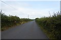
Cockleton Lane
Looking along Cockleton Lane leading from Northwood towards Gurnard.
Image: © DS Pugh
Taken: 29 Aug 2016
0.08 miles
2
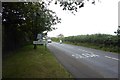
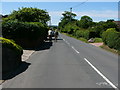
Edge of Northwood
The sign for Northwood along Place Road. The road comes from Cowes.
Image: © DS Pugh
Taken: 29 Aug 2016
0.09 miles
3
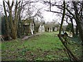
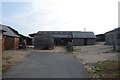
Nissen Huts
Old WW2 Nissen Huts still in use on farmland at Place Side.
Image: © Mark Pilbeam
Taken: 3 Jan 2006
0.18 miles
4

Footpath to Place Road
A footpath linking Three Gates Road and Place Road.
Image: © DS Pugh
Taken: 29 Aug 2016
0.20 miles
5
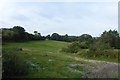
Track off Cockleton Lane
Rough grazing off Cockleton Lane.
Image: © DS Pugh
Taken: 29 Aug 2016
0.22 miles
7
Cockleton Farm
Riding stables along Cockleton Lane.
Image: © DS Pugh
Taken: 29 Aug 2016
0.24 miles
8
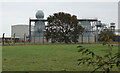
BAE Systems radar towers
The site which was formerly Plessey Radar and, before that, Somerton Airfield.
Image: © Paul Coueslant
Taken: 19 Oct 2021
0.24 miles