IMAGES TAKEN NEAR TO
Bay View Road, COWES, PO31 8JF
Introduction
This page details the photographs taken nearby to Bay View Road, PO31 8JF by members of the Geograph project.
The Geograph project started in 2005 with the aim of publishing, organising and preserving representative images for every square kilometre of Great Britain, Ireland and the Isle of Man.

There are currently over 7.5m images from over14,400 individuals and you can help contribute to the project by visiting https://www.geograph.org.uk
Image Map
Images are licensed for reuse under creativecommons.org/licenses/by-sa/2.0
Notes
- Clicking on the map will re-center to the selected point.
- The higher the marker number, the further away the image location is from the centre of the postcode.
Image Listing (27 Images Found)
Images are licensed for reuse under creativecommons.org/licenses/by-sa/2.0
Image
Details
Distance
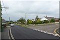
1
Church Road
Looking at houses on the corner of Church Road and Cockleton Lane.
Image: © DS Pugh
Taken: 29 Aug 2016
0.05 miles
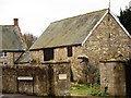
2
Gurnard Farm
Looking across Cockleton Lane from Church Road.
Image: © DS Pugh
Taken: 29 Aug 2016
0.08 miles
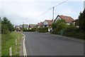
3
Looking up Church Road
One of the streets in Gurnard near to its junction with Cockleton Lane.
Image: © DS Pugh
Taken: 29 Aug 2016
0.08 miles
4
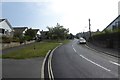
Down Church Road
Looking down Church Road at the junction with Tilbury Road in Gurnard.
Image: © DS Pugh
Taken: 29 Aug 2016
0.08 miles
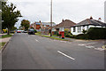
6
Entering Gurnard
Houses along Cockleton Lane in Gurnard.
Image: © DS Pugh
Taken: 29 Aug 2016
0.12 miles
7
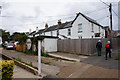
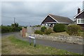
Coastguard Cottages on Solent View Road, Gurnard
Image: © Ian S
Taken: 19 Aug 2015
0.13 miles
8
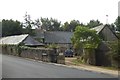
Gurnard Farm
A new approach to "Rare Breeds" farming perhaps?
Image: © Mark Pilbeam
Taken: 3 Jan 2006
0.13 miles
9
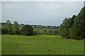
Fields on the outskirts of Gurnard
Looking across farmland from Cockleton Lane.
Image: © DS Pugh
Taken: 29 Aug 2016
0.14 miles