IMAGES TAKEN NEAR TO
Union Road, COWES, PO31 7TW
Introduction
This page details the photographs taken nearby to Union Road, PO31 7TW by members of the Geograph project.
The Geograph project started in 2005 with the aim of publishing, organising and preserving representative images for every square kilometre of Great Britain, Ireland and the Isle of Man.

There are currently over 7.5m images from over14,400 individuals and you can help contribute to the project by visiting https://www.geograph.org.uk
Image Map
Images are licensed for reuse under creativecommons.org/licenses/by-sa/2.0
Notes
- Clicking on the map will re-center to the selected point.
- The higher the marker number, the further away the image location is from the centre of the postcode.
Image Listing (538 Images Found)
Images are licensed for reuse under creativecommons.org/licenses/by-sa/2.0
Image
Details
Distance
1
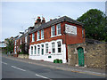
The former Wheatsheaf Pub
In Terminus Road, Cowes. The premises are now to let for use as office space.
Image: © John Lucas
Taken: 5 Jun 2008
0.02 miles
2
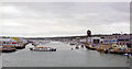
Medina Estuary at Cowes, 2004
View southwards from a ferry from Cowes to East Cowes. This was the best I could do to get a photograph of the site of Mill Hill (IoW) station, which had been over to the right on the ex-IoW Central Newport - Cowes branch until the line was closed from 21/2/66.
Image: © Ben Brooksbank
Taken: 23 Sep 2004
0.02 miles
4
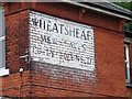
The Wheatsheaf, Terminus Road, Cowes
The painted sign has been preserved on the old pub building even though it appears not to have been used as such for many years.
Image: © John Lucas
Taken: 5 Jun 2008
0.03 miles
5
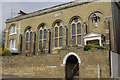
Cowes Roman Catholic Church
This church has an unusual archway entrance from the street - not ideal for elderly or disabled members of the congregation. Note that the presbytery is part of the church building. The name of the street is a reminder that Cowes station was once nearby.
Image: © Stephen McKay
Taken: 7 Apr 2007
0.04 miles
6
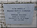
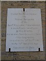
St Thomas of Canterbury RC Church: memorial (i)
Also see http://stmarysryde.org/aboutus/martyrs.php
Image: © Basher Eyre
Taken: 30 Dec 2014
0.05 miles
7
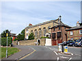
St Thomas Of Canterbury's Roman Catholic Church
In Terminus Road, Cowes.
Image: © John Lucas
Taken: 5 Jun 2008
0.05 miles
8
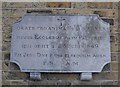
St Thomas of Canterbury RC Church: memorial (ii)
Image: © Basher Eyre
Taken: 30 Dec 2014
0.05 miles
9
St Thomas of Canterbury RC Church: memorial (iii)
Image: © Basher Eyre
Taken: 30 Dec 2014
0.05 miles
10
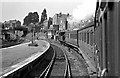
Departure from Cowes
The railway no longer runs from Cowes, the line from here to Newport and Ryde having been closed in 1967. Part of the Newport - Ryde line is now operated by the Isle of Wight Steam Railway.
I haven't visited the area for many years but according to my Explorer map, the road bridge on the left still survives.
Image: © John Lucas
Taken: Unknown
0.05 miles