IMAGES TAKEN NEAR TO
Firs Close, COWES, PO31 7NF
Introduction
This page details the photographs taken nearby to Firs Close, PO31 7NF by members of the Geograph project.
The Geograph project started in 2005 with the aim of publishing, organising and preserving representative images for every square kilometre of Great Britain, Ireland and the Isle of Man.

There are currently over 7.5m images from over14,400 individuals and you can help contribute to the project by visiting https://www.geograph.org.uk
Image Map
Images are licensed for reuse under creativecommons.org/licenses/by-sa/2.0
Notes
- Clicking on the map will re-center to the selected point.
- The higher the marker number, the further away the image location is from the centre of the postcode.
Image Listing (6 Images Found)
Images are licensed for reuse under creativecommons.org/licenses/by-sa/2.0
Image
Details
Distance
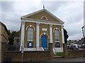
1
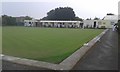
Plessey bowls club
On the outskirts of Cowes.
Image: © andrew auger
Taken: 27 Aug 2016
0.04 miles
2
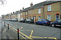
Park Road
One of the main roads into Cowes, with a row of good quality two-up, two-down terraced houses fronting the street. Note "two-up two-down" refers to a characteristic workers' property of the 19th and 20th centuries comprising two rooms upstairs and two rooms downstairs.
Image: © Graham Horn
Taken: 27 Dec 2012
0.17 miles
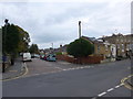
3
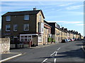
Park Road, Cowes
View of some terraced housing at the junction of Victoria Road.
Image: © Ian Paterson
Taken: 20 Jun 2010
0.17 miles
5
Farewell to an old friend
I clicked my trusty old work horse, it captured this final image at the junction of Victoria and Moorgreen Roads, then "stopped short, never to go again"!
Image: © Basher Eyre
Taken: 17 Oct 2015
0.25 miles