IMAGES TAKEN NEAR TO
Newport Road, COWES, PO31 7LW
Introduction
This page details the photographs taken nearby to Newport Road, PO31 7LW by members of the Geograph project.
The Geograph project started in 2005 with the aim of publishing, organising and preserving representative images for every square kilometre of Great Britain, Ireland and the Isle of Man.

There are currently over 7.5m images from over14,400 individuals and you can help contribute to the project by visiting https://www.geograph.org.uk
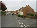
Image Map
Images are licensed for reuse under creativecommons.org/licenses/by-sa/2.0
Notes
- Clicking on the map will re-center to the selected point.
- The higher the marker number, the further away the image location is from the centre of the postcode.
Image Listing (140 Images Found)
Images are licensed for reuse under creativecommons.org/licenses/by-sa/2.0
Image
Details
Distance
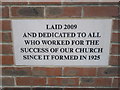
2

Cowes Spiritualist Church, Newport Road: October 2015
Image: © Basher Eyre
Taken: 17 Oct 2015
0.05 miles
3
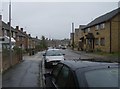
Arctic Road
A residential street to the south of Cowes town centre. Despite its unprepossessing suburban appearance, this street is frequently used by cyclists and walkers as it accesses National Cycle Route 23 between Cowes and Newport.
Image: © Graham Horn
Taken: 29 Sep 2007
0.05 miles
4
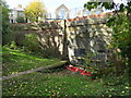
Former railway tunnel, Cowes
This image was taken at the site of the former Mill Hill station in Cowes. The station closed in 1966. Nevertheless, the platform edge is still visible, leading to the mouth of a tunnel which took the railway towards its terminus in the centre of Cowes. This end of the former station is now a small park.
More information about Mill Hill station can be found on the Disused Stations website: http://www.disused-stations.org.uk/m/mill_hill/index.shtml
Image: © Malc McDonald
Taken: 15 Oct 2020
0.06 miles
5
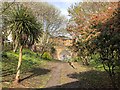
Site of former Mill Hill Station
Opened in 1871 on the Cowes and Newport line, the station closed in February 1966 and the site was cleared for housing in 1985. The tunnel led to the terminus at Cowes, the next station on the line.
Image: © Paul Coueslant
Taken: 10 Apr 2019
0.06 miles
6
Arctic Road, Cowes
Arctic Road is a residential road in Cowes, on the Isle of Wight.
Image: © Malc McDonald
Taken: 14 Oct 2020
0.08 miles
7
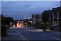
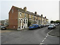
Newport Road
Looking along Newport Road in the evening.
Image: © DS Pugh
Taken: 28 Aug 2016
0.09 miles
8
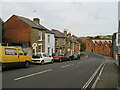
Bridge Road, Cowes
Bridge Road is a residential road in Cowes. It forms the B3320, a very short 'B' road which is only a few hundred metres in length: https://www.sabre-roads.org.uk/wiki/index.php?title=B3320
Bridge Road also forms part of National Cycle Network route 23, and the Isle of Wight's Red Squirrel Trail.
Image: © Malc McDonald
Taken: 14 Oct 2020
0.10 miles
9
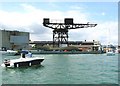
Cowes Hammerhead Crane
One of the last remaining symbols of the boat building industry in Cowes - placed under a preservation order when the boatyard closed in 2004 but there are now concerns over the safety of the structure.
Image: © Mark Pilbeam
Taken: 11 Jun 2005
0.11 miles
10
Pelham Road, Cowes
A housing terrace on Pelham Road in Cowes, on the Isle of Wight.
Image: © Malc McDonald
Taken: 14 Oct 2020
0.11 miles