IMAGES TAKEN NEAR TO
Maxted Close, COWES, PO31 7LL
Introduction
This page details the photographs taken nearby to Maxted Close, PO31 7LL by members of the Geograph project.
The Geograph project started in 2005 with the aim of publishing, organising and preserving representative images for every square kilometre of Great Britain, Ireland and the Isle of Man.

There are currently over 7.5m images from over14,400 individuals and you can help contribute to the project by visiting https://www.geograph.org.uk
Image Map
Images are licensed for reuse under creativecommons.org/licenses/by-sa/2.0
Notes
- Clicking on the map will re-center to the selected point.
- The higher the marker number, the further away the image location is from the centre of the postcode.
Image Listing (7 Images Found)
Images are licensed for reuse under creativecommons.org/licenses/by-sa/2.0
Image
Details
Distance
1
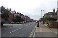
Letterbox on Mill Hill Road
The street opposite is Stephenson Road.
Image: © DS Pugh
Taken: 29 Aug 2016
0.07 miles
2
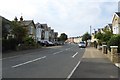
Looking along Mill Hill Road
From the junction with Grove Road.
Image: © DS Pugh
Taken: 29 Aug 2016
0.10 miles
3
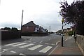
Zebra crossing on Mill Hill Road
The road opposite is St. Faith's Road.
Image: © DS Pugh
Taken: 29 Aug 2016
0.11 miles
4
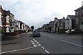
Down Mill Hill Road
Looking down Mill Hill Road at the junction of Grove Road.
Image: © DS Pugh
Taken: 29 Aug 2016
0.15 miles
5
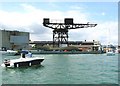
Cowes Hammerhead Crane
One of the last remaining symbols of the boat building industry in Cowes - placed under a preservation order when the boatyard closed in 2004 but there are now concerns over the safety of the structure.
Image: © Mark Pilbeam
Taken: 11 Jun 2005
0.21 miles
7
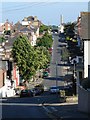
Down Victoria Road
Looking south-east down (and up) Victoria Road, Cowes.
Image: © Ian Paterson
Taken: 20 Jun 2010
0.24 miles