IMAGES TAKEN NEAR TO
Deauville Avenue, COWES, PO31 7GA
Introduction
This page details the photographs taken nearby to Deauville Avenue, PO31 7GA by members of the Geograph project.
The Geograph project started in 2005 with the aim of publishing, organising and preserving representative images for every square kilometre of Great Britain, Ireland and the Isle of Man.

There are currently over 7.5m images from over14,400 individuals and you can help contribute to the project by visiting https://www.geograph.org.uk
Image Map
Images are licensed for reuse under creativecommons.org/licenses/by-sa/2.0
Notes
- Clicking on the map will re-center to the selected point.
- The higher the marker number, the further away the image location is from the centre of the postcode.
Image Listing (23 Images Found)
Images are licensed for reuse under creativecommons.org/licenses/by-sa/2.0
Image
Details
Distance
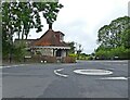
1
The Roundhouse
On the roundabout at the junction of park Road and Place Road going into Cowes.
Image: © Mark Pilbeam
Taken: 20 Nov 2005
0.10 miles
3
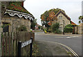
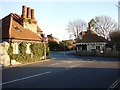
Listed buildings, West Cowes
The Grade 2-listed former Northwood Park lodge (circa 1837) shown across the road and, in the foreground, part of the Grade 2-star listed 'round house', an early 19th century toll gate or lodge.
Image: © Paul Coueslant
Taken: 19 Oct 2021
0.14 miles