IMAGES TAKEN NEAR TO
Love Lane, COWES, PO31 7EU
Introduction
This page details the photographs taken nearby to Love Lane, PO31 7EU by members of the Geograph project.
The Geograph project started in 2005 with the aim of publishing, organising and preserving representative images for every square kilometre of Great Britain, Ireland and the Isle of Man.

There are currently over 7.5m images from over14,400 individuals and you can help contribute to the project by visiting https://www.geograph.org.uk
Image Map
Images are licensed for reuse under creativecommons.org/licenses/by-sa/2.0
Notes
- Clicking on the map will re-center to the selected point.
- The higher the marker number, the further away the image location is from the centre of the postcode.
Image Listing (14 Images Found)
Images are licensed for reuse under creativecommons.org/licenses/by-sa/2.0
Image
Details
Distance
1
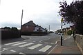
Zebra crossing on Mill Hill Road
The road opposite is St. Faith's Road.
Image: © DS Pugh
Taken: 29 Aug 2016
0.05 miles
2
Letterbox on Mill Hill Road
The street opposite is Stephenson Road.
Image: © DS Pugh
Taken: 29 Aug 2016
0.08 miles
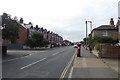
3
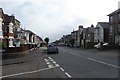
Looking along Mill Hill Road
From the junction with Grove Road.
Image: © DS Pugh
Taken: 29 Aug 2016
0.17 miles
5

Bus stop on Newport Road
Situated next to Northwood Cemetery.
Image: © DS Pugh
Taken: 29 Aug 2016
0.20 miles
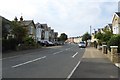
7
Down Mill Hill Road
Looking down Mill Hill Road at the junction of Grove Road.
Image: © DS Pugh
Taken: 29 Aug 2016
0.22 miles
8

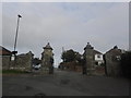
Building work at Northwood Cemetery
Looking into the cemetery from Newport Road.
Image: © DS Pugh
Taken: 29 Aug 2016
0.22 miles
9
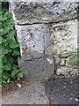
Cut bench mark on wall of Northwood Cemetery
See http://www.bench-marks.org.uk/bm44417 for details.
Image: © Brian Westlake
Taken: 19 Jun 2012
0.22 miles
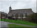
10

Not amused either?
With Queen Victoria living nearby, maybe he daren't!
(taken at Northwood Cemetery Chapel)
Image: © Basher Eyre
Taken: 18 Oct 2015
0.22 miles