IMAGES TAKEN NEAR TO
Pallance Gate, NEWPORT, PO30 5UA
Introduction
This page details the photographs taken nearby to Pallance Gate, PO30 5UA by members of the Geograph project.
The Geograph project started in 2005 with the aim of publishing, organising and preserving representative images for every square kilometre of Great Britain, Ireland and the Isle of Man.

There are currently over 7.5m images from over14,400 individuals and you can help contribute to the project by visiting https://www.geograph.org.uk
Image Map
Images are licensed for reuse under creativecommons.org/licenses/by-sa/2.0
Notes
- Clicking on the map will re-center to the selected point.
- The higher the marker number, the further away the image location is from the centre of the postcode.
Image Listing (7 Images Found)
Images are licensed for reuse under creativecommons.org/licenses/by-sa/2.0
Image
Details
Distance
1
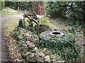
Farm sculpture at Pallancegate
An old plough and a more recent lorry tyre have been made into an sculpture feature along the lane.
Image: © Graham Horn
Taken: 29 Sep 2007
0.00 miles
2
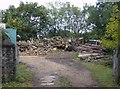
Timber yard at Pallancegate
A small-scale timber cutting and sorting operation.
Image: © Graham Horn
Taken: 29 Sep 2007
0.06 miles
3
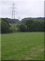
Pylons at Pallancegate
The pylons cross the north-eastern part of the square. Here they skirt Rough Copse in the foreground and head through Crockers Copse (next square) behind.
Image: © Graham Horn
Taken: 29 Sep 2007
0.14 miles
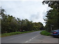
4
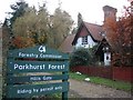
A track leading to Mark's Corner, Parkhurst Forest
Image: © Ian S
Taken: 16 Oct 2011
0.16 miles
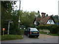
6
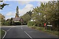
Hillisgate junction for Mark's Corner
Image: © Paul Coueslant
Taken: 17 Oct 2020
0.17 miles