IMAGES TAKEN NEAR TO
Pound Lane, NEWPORT, PO30 4JX
Introduction
This page details the photographs taken nearby to Pound Lane, PO30 4JX by members of the Geograph project.
The Geograph project started in 2005 with the aim of publishing, organising and preserving representative images for every square kilometre of Great Britain, Ireland and the Isle of Man.

There are currently over 7.5m images from over14,400 individuals and you can help contribute to the project by visiting https://www.geograph.org.uk
Image Map
Images are licensed for reuse under creativecommons.org/licenses/by-sa/2.0
Notes
- Clicking on the map will re-center to the selected point.
- The higher the marker number, the further away the image location is from the centre of the postcode.
Image Listing (4 Images Found)
Images are licensed for reuse under creativecommons.org/licenses/by-sa/2.0
Image
Details
Distance
1
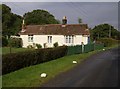
Pound Crossing
This is the former crossing-keeper's cottage. The Yarmouth to Newport railway line crossed here, just in front of the cottage where the hedge and the fence join. The line closed in September 1953.
Image: © Graham Horn
Taken: 30 Sep 2007
0.05 miles
2
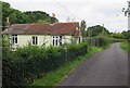
Pound Lane
The former railway crossing keeper's cottage on the Freshwater, Yarmouth and Newport line which closed in 1953.
Image: © Paul Coueslant
Taken: 22 Aug 2017
0.08 miles
3
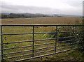
Farmland off Pound Lane
The square is mainly arable farmland, with some woodland. Here, at the eastern side of the square of Pound Lane there is a substantial field headland full of pheasants, before a recently cut cereal crop field. The transmitter on the horizon is Rowridge, two miles away.
Image: © Graham Horn
Taken: 30 Sep 2007
0.10 miles
4
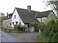
House on Pound Lane
An attractive and substantial property just a few yards from the A3054 on a quiet lane, giving easy access to Newport. (I sound like an Estate Agent!)
Image: © Graham Horn
Taken: 30 Sep 2007
0.21 miles