IMAGES TAKEN NEAR TO
Brook, NEWPORT, PO30 4EJ
Introduction
This page details the photographs taken nearby to PO30 4EJ by members of the Geograph project.
The Geograph project started in 2005 with the aim of publishing, organising and preserving representative images for every square kilometre of Great Britain, Ireland and the Isle of Man.

There are currently over 7.5m images from over14,400 individuals and you can help contribute to the project by visiting https://www.geograph.org.uk
Image Map
Images are licensed for reuse under creativecommons.org/licenses/by-sa/2.0
Notes
- Clicking on the map will re-center to the selected point.
- The higher the marker number, the further away the image location is from the centre of the postcode.
Image Listing (49 Images Found)
Images are licensed for reuse under creativecommons.org/licenses/by-sa/2.0
Image
Details
Distance
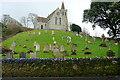
1
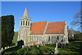
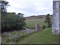
St Mary's church, Brook
St Mary's church is prominent on a rise some distance north of the village it serves, with an unusual steeply-sloping churchyard. The present church was built in 1864 after the previous building burned down.
Image: © Ron Strutt
Taken: 5 Oct 2005
0.16 miles
2
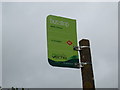
Bus Stop at Brook Triangle
This photo shows a Southern Vectis bus stop on the B3399 road North of Brook. The mentioned Route 12 runs from Totland to Newport via Freshwater, Brighstone, Shorwell and Carisbrooke. Southern Vectis is known as "the island's buses" as indicated on the bus stop.
Image: © David Hillas
Taken: 8 Jul 2011
0.17 miles
4
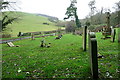
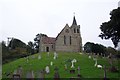
Brook churchyard
Looking north from the bottom of the steps leading up to the church, up to the right. The view is towards the downs that form the chalk spine of the Isle of Wight.
Image: © Graham Horn
Taken: 26 Dec 2012
0.21 miles
5
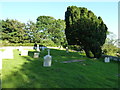
Somewhat less balmy than last time
My last visit to Brook Churchyard was on an altogether more pleasant day http://www.geograph.org.uk/photo/3148212
Image: © Basher Eyre
Taken: 6 Oct 2018
0.21 miles
6
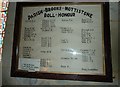
Inside St Mary, Brook (9)
Pevsner ("The buildings of Hampshire and the Isle of Wight) Harmondsworth,Penguin, 1967; repr 1973 ISBN 0140710329) tells us the church dates back to the C13 and was renovated in 1864 by Malling: this is the parishes roll of honour. See also http://www.isle-of-wight-fhs.co.uk/mis_bis/mis_mottistone_ss_peter_paul.htm
Image: © Basher Eyre
Taken: 24 Jul 2012
0.21 miles
7
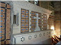
Inside St Mary, Brook (17)
Pevsner ("The buildings of Hampshire and the Isle of Wight) Harmondsworth,Penguin, 1967; repr 1973 ISBN 0140710329) tells us the church dates back to the C13 and was renovated in 1864 by Malling: this is the reredos.
Image: © Basher Eyre
Taken: 24 Jul 2012
0.21 miles
8
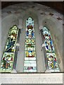
Inside St Mary, Brook (19)
Pevsner ("The buildings of Hampshire and the Isle of Wight) Harmondsworth,Penguin, 1967; repr 1973 ISBN 0140710329) tells us the church dates back to the C13 and was renovated in 1864 by Malling: this is the stained glass window above the altar.
Image: © Basher Eyre
Taken: 24 Jul 2012
0.21 miles
9
Brook church
Dedicated to St. Mary, this is Victorian, replacing the Medieval church that burned down in 1862 or 1863 (sources vary). It has memorials to the Brook lifeboat.
Image: © Graham Horn
Taken: 26 Dec 2012
0.21 miles