IMAGES TAKEN NEAR TO
Main Road, NEWPORT, PO30 3BR
Introduction
This page details the photographs taken nearby to Main Road, PO30 3BR by members of the Geograph project.
The Geograph project started in 2005 with the aim of publishing, organising and preserving representative images for every square kilometre of Great Britain, Ireland and the Isle of Man.

There are currently over 7.5m images from over14,400 individuals and you can help contribute to the project by visiting https://www.geograph.org.uk
Image Map
Images are licensed for reuse under creativecommons.org/licenses/by-sa/2.0
Notes
- Clicking on the map will re-center to the selected point.
- The higher the marker number, the further away the image location is from the centre of the postcode.
Image Listing (13 Images Found)
Images are licensed for reuse under creativecommons.org/licenses/by-sa/2.0
Image
Details
Distance
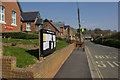
1
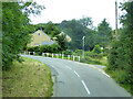
Bend on main road through Chillerton
Brook Lane leaves on the right and immediately passes through a ford.
Image: © Robin Webster
Taken: 16 Jul 2017
0.02 miles
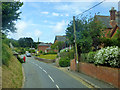
2
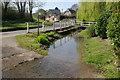
Chillerton
Looking towards the centre of the village. The ford in the foreground is Brook Lane, giving access to a handful of houses. It is also a bridleway.
Image: © Stephen McKay
Taken: 8 Apr 2007
0.02 miles
3

Chillerton Ford
This is the ford at Chillerton and features Mika.
Image: © John Walton
Taken: 20 Sep 2020
0.03 miles
5
Road towards Chillerton
A view from a southbound route 6 bus.
Image: © Robin Webster
Taken: 16 Jul 2017
0.05 miles
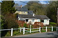
6
Chillerton
The building on the left is Chillerton and Rookley Primary School.
Image: © Stephen McKay
Taken: 8 Apr 2007
0.09 miles
7
Main road, Chillerton
The man in red is standing outside the bus shelter, which is full of cut scrub like the heap outside. Presumably he is waiting for something to come to take it away. It was not the bus!
Image: © Robin Webster
Taken: 16 Jul 2017
0.10 miles
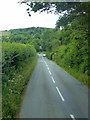
8

Public path Gatcombe to Chillerton
Limited views on the descent to Chillerton village in this tunnel of green.
Image: © Paul Coueslant
Taken: 11 Aug 2017
0.20 miles
9
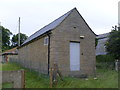
Chillerton Telephone Exchange, IoW (1)
This TE is situated off a track near Sheat Farm and has the code SDCHLLR. It provides telephone and broadband services to 420 residential and 62 non-residential premises in Chillerton, plus Gatcombe and Rookley nearby. The louvres can be seen on its side, whilst the original grey door is at the front. This TE has (01983) 721xxx numbers, the (01983) referring to the Isle of Wight group of sixteen TEs, whilst the postcode is PO30 3EN.
Image: © David Hillas
Taken: 6 Jul 2011
0.21 miles
10
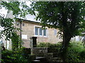
Chillerton Telephone Exchange, IoW (2)
This photo, taken from the track leading to Brook Lane, shows the steps and gate leading to the TE and the BT warning notice on it.
Image: © David Hillas
Taken: 5 Jul 2011
0.21 miles