IMAGES TAKEN NEAR TO
Furrlongs, NEWPORT, PO30 2BU
Introduction
This page details the photographs taken nearby to Furrlongs, PO30 2BU by members of the Geograph project.
The Geograph project started in 2005 with the aim of publishing, organising and preserving representative images for every square kilometre of Great Britain, Ireland and the Isle of Man.

There are currently over 7.5m images from over14,400 individuals and you can help contribute to the project by visiting https://www.geograph.org.uk
Image Map
Images are licensed for reuse under creativecommons.org/licenses/by-sa/2.0
Notes
- Clicking on the map will re-center to the selected point.
- The higher the marker number, the further away the image location is from the centre of the postcode.
Image Listing (10 Images Found)
Images are licensed for reuse under creativecommons.org/licenses/by-sa/2.0
Image
Details
Distance
1
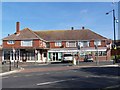
Staplers Road, Newport
On the town outskirts.
Image: © Robin Webster
Taken: 9 Oct 2016
0.05 miles
2
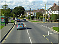
Staplers Road
11930s(?) housing on Staplers Road, by its junction with Mayfield Drive.
Image: © Ian Capper
Taken: 13 Jul 2009
0.08 miles
4

Bellecroft House
18th Century mansion, now converted into flats. Grade II* listed - see www.historicengland.org.uk/listing/the-list/list-entry/1233835.
Image: © Ian Capper
Taken: 13 Jul 2009
0.10 miles
5
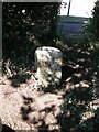
Old Boundary Marker at the junction of Staplers Road and Long Lane
Parish Boundary Marker now moved to the centre of a roundabout at the junction of Staplers Road and Long Lane. Formerly on the border of Whippingham and North Arreton parishes but now entirely in Newport and Carisbrooke parish. Inscribed W P (Whippingham Parish).
Milestone Society National ID: IW_NEWCAR02pb
Image: © D Pitcher
Taken: Unknown
0.11 miles
6
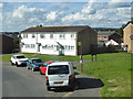
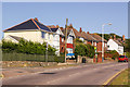
Houses on Furrlongs, Newport
In the fairly modern eastern suburbs of Newport. The bus stop is for route 8. The road is also served by town circular route 39, but that only runs in the opposite direction.
Image: © Robin Webster
Taken: 9 Oct 2016
0.11 miles
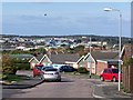
7
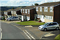
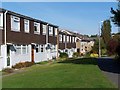
Houses on Furrlongs, Newport
In the fairly modern eastern suburbs of Newport.
Image: © Robin Webster
Taken: 9 Oct 2016
0.14 miles
8
View from Pan Country Park
The path across the park leading to Beauchamp Drive.
Image: © Paul Coueslant
Taken: 15 Oct 2021
0.14 miles
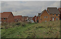
9
Mayfield Drive, with distant view over Newport
The distant view is across the Medina Valley, with Newport's extensive industrial and commercial sprawl much in evidence
Image: © David Martin
Taken: 18 Oct 2009
0.18 miles