IMAGES TAKEN NEAR TO
Bersted Mews, Bersted Street, BOGNOR REGIS, PO22 9RR
Introduction
This page details the photographs taken nearby to Bersted Mews, Bersted Street, PO22 9RR by members of the Geograph project.
The Geograph project started in 2005 with the aim of publishing, organising and preserving representative images for every square kilometre of Great Britain, Ireland and the Isle of Man.

There are currently over 7.5m images from over14,400 individuals and you can help contribute to the project by visiting https://www.geograph.org.uk
Image Map
Images are licensed for reuse under creativecommons.org/licenses/by-sa/2.0
Notes
- Clicking on the map will re-center to the selected point.
- The higher the marker number, the further away the image location is from the centre of the postcode.
Image Listing (71 Images Found)
Images are licensed for reuse under creativecommons.org/licenses/by-sa/2.0
Image
Details
Distance
3
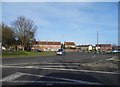
Approaching roundabout along Highfields Road, Bognor Regis
Image: © Jeff Gogarty
Taken: 22 Jun 2020
0.07 miles
4
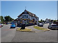
Premier Express on Highfields Road/Gordon Ave junction
Image: © Jeff Gogarty
Taken: 22 Jun 2020
0.07 miles
5
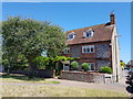
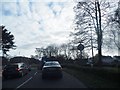
House on corner of Shripney Road and Ivy Lane
Image: © Jeff Gogarty
Taken: 22 Jun 2020
0.08 miles
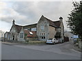
6
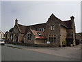
The Old School Nursery, Bersted Street
Image: © Jeff Gogarty
Taken: 16 Jun 2020
0.09 miles
7
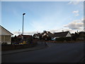
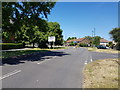
Junction of St Mary's Close and Bersted Road
Image: © Basher Eyre
Taken: 28 Feb 2016
0.10 miles
8
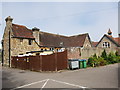
Rear of The Old School Nursery, Bersted Street
Image: © Jeff Gogarty
Taken: 16 Jun 2020
0.10 miles
10
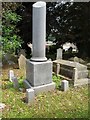
Interesting Memorial in St Mary Magdalene graveyard
Image: © Jeff Gogarty
Taken: 16 Jun 2020
0.11 miles