IMAGES TAKEN NEAR TO
Markfield, BOGNOR REGIS, PO22 9HW
Introduction
This page details the photographs taken nearby to Markfield, PO22 9HW by members of the Geograph project.
The Geograph project started in 2005 with the aim of publishing, organising and preserving representative images for every square kilometre of Great Britain, Ireland and the Isle of Man.

There are currently over 7.5m images from over14,400 individuals and you can help contribute to the project by visiting https://www.geograph.org.uk
Image Map
Images are licensed for reuse under creativecommons.org/licenses/by-sa/2.0
Notes
- Clicking on the map will re-center to the selected point.
- The higher the marker number, the further away the image location is from the centre of the postcode.
Image Listing (4 Images Found)
Images are licensed for reuse under creativecommons.org/licenses/by-sa/2.0
Image
Details
Distance
1
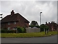
Junction of Whiteways and Burton Road, North Bersted
Image: © Jeff Gogarty
Taken: 18 Jun 2020
0.15 miles
2
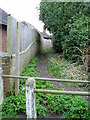
Start of footpath 141
Public footpath from North Bersted Street to Woodlands Road,
Image: © Peter Holmes
Taken: 10 Mar 2012
0.16 miles
3
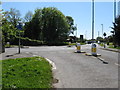
Roundabout at the junction of North Bersted Street and Rowan Way
Image: © Dave Spicer
Taken: 16 May 2013
0.19 miles
4
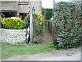
Path between North Bersted Street and Shripney Lane
Public Footpath 145.
Image: © Peter Holmes
Taken: 10 Mar 2012
0.22 miles