IMAGES TAKEN NEAR TO
The Dell, BOGNOR REGIS, PO22 9AZ
Introduction
This page details the photographs taken nearby to The Dell, PO22 9AZ by members of the Geograph project.
The Geograph project started in 2005 with the aim of publishing, organising and preserving representative images for every square kilometre of Great Britain, Ireland and the Isle of Man.

There are currently over 7.5m images from over14,400 individuals and you can help contribute to the project by visiting https://www.geograph.org.uk
Image Map
Images are licensed for reuse under creativecommons.org/licenses/by-sa/2.0
Notes
- Clicking on the map will re-center to the selected point.
- The higher the marker number, the further away the image location is from the centre of the postcode.
Image Listing (24 Images Found)
Images are licensed for reuse under creativecommons.org/licenses/by-sa/2.0
Image
Details
Distance
1
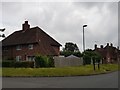
Junction of Whiteways and Burton Road, North Bersted
Image: © Jeff Gogarty
Taken: 18 Jun 2020
0.10 miles
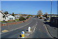
3
Chichester Road, North Bersted, Bognor Regis
Image: © Jeff Gogarty
Taken: 18 Jun 2020
0.16 miles
4
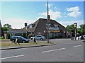
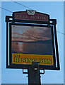
The Rising Sun (formerly The Bersted Tavern) (1), 351 Chichester Road, North Bersted
There was a Rising Sun pub here in Victorian times. One of the landlords, Richard Sharpe, was obsessed with covering one room and its furniture with postage stamps. As a result it was popularly known as the Jubilee Stamp-house, and became a visitor attraction because of that. Eventually the pub was closed and demolished in 1957. What became of the stamps isn't clear.
The present larger pub was built on the site of the old one. For some time it was known as The Bersted Tavern, and then at some point reverted to the name of The Rising Sun. There are on the internet photos of the old pub, and the new pub when it was known as The Bersted Tavern. The links aren't given here because external links often change or become dead, but a search will easily unearth the photos.
Image
Image
Image: © P L Chadwick
Taken: 28 May 2010
0.16 miles
5
The Rising Sun (2) - pub sign, 351 Chichester Road, North Bersted
An imaginative interpretation of a rising sun, which makes a change from the usual yellow face, with points all around it.
Image
Image
Image: © P L Chadwick
Taken: 28 May 2010
0.16 miles
6
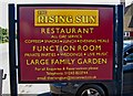
The Rising Sun (3) - information board, 351 Chichester Road, North Bersted
These days The Rising Sun is as much a restaurant, as a pub. It does have live music at times.
Image
Image
Image: © P L Chadwick
Taken: 28 May 2010
0.16 miles
7
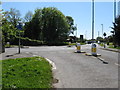
Roundabout at the junction of North Bersted Street and Rowan Way
Image: © Dave Spicer
Taken: 16 May 2013
0.17 miles
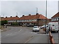
8
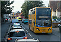
Chichester Road
A busy scene on the B2259 in North Bersted - exacerbated by a queue for fuel the other side of the roundabouts up ahead. The bus approaching is on the Coastliner 700 service from Portsmouth. Serving Havant and Chichester on route to Bognor Regis, it will terminate at Flansham Park with an onward connection to Littlehampton.
Image: © Martin Addison
Taken: 25 Sep 2021
0.17 miles
9
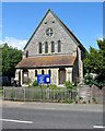
Holy Cross Church, Chichester Road, North Bersted
This Anglican church is situated on Chichester Road, and very near to the Royal Oak pub. The origins of the church lies in a thatched cottage, formerly a blacksmiths, which in 1880 was licensed by the Bishop for divine service. In 1894 a mission hall was built, which forms the present nave. As the population of North Bersted grew, so the church was enlarged. A Chancel was added in 1930, and enlarged further in 1973.
Image
Image: © P L Chadwick
Taken: 28 May 2010
0.17 miles
10
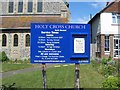
Holy Cross Church noticeboard, Chichester Road, North Bersted
The house, part of which can be seen on the right, is the Vicarage. The notice being displayed, was advertising a Plant Sale.
Image
Image: © P L Chadwick
Taken: 28 May 2010
0.17 miles