IMAGES TAKEN NEAR TO
Fitzwilliam Close, BOGNOR REGIS, PO21 5RY
Introduction
This page details the photographs taken nearby to Fitzwilliam Close, PO21 5RY by members of the Geograph project.
The Geograph project started in 2005 with the aim of publishing, organising and preserving representative images for every square kilometre of Great Britain, Ireland and the Isle of Man.

There are currently over 7.5m images from over14,400 individuals and you can help contribute to the project by visiting https://www.geograph.org.uk
Image Map
Images are licensed for reuse under creativecommons.org/licenses/by-sa/2.0
Notes
- Clicking on the map will re-center to the selected point.
- The higher the marker number, the further away the image location is from the centre of the postcode.
Image Listing (6 Images Found)
Images are licensed for reuse under creativecommons.org/licenses/by-sa/2.0
Image
Details
Distance
3
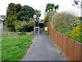
Route from Yeomans Acre to Oxford Drive
Public footpath 140.
Image: © Peter Holmes
Taken: 14 Apr 2012
0.21 miles
4
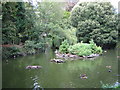
Aldwick Duck Pond
This is a quiet residential area with several open areas including Aldwick duck pond and Aldwick Green. These are well maintained by the Aldwick Green Conservation Society.
Image: © Richard William Thomas
Taken: 31 Aug 2006
0.23 miles
5
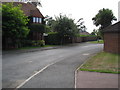
typical housing and treescape
A typical small estate in this grid square built on the site of a Banardo's home. The area has a rich mixture of mature deciduous and evergreen trees.
Image: © Richard William Thomas
Taken: 31 Aug 2006
0.23 miles
6
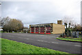
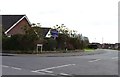
Fire Station, Bognor Regis
In West Meads Drive.
Image: © Robin Webster
Taken: 12 Feb 2007
0.24 miles