IMAGES TAKEN NEAR TO
Gravits Lane, BOGNOR REGIS, PO21 5LW
Introduction
This page details the photographs taken nearby to Gravits Lane, PO21 5LW by members of the Geograph project.
The Geograph project started in 2005 with the aim of publishing, organising and preserving representative images for every square kilometre of Great Britain, Ireland and the Isle of Man.

There are currently over 7.5m images from over14,400 individuals and you can help contribute to the project by visiting https://www.geograph.org.uk
Image Map
Images are licensed for reuse under creativecommons.org/licenses/by-sa/2.0
Notes
- Clicking on the map will re-center to the selected point.
- The higher the marker number, the further away the image location is from the centre of the postcode.
Image Listing (7 Images Found)
Images are licensed for reuse under creativecommons.org/licenses/by-sa/2.0
Image
Details
Distance
1
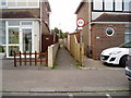
Twitten from Kenilworth Road
Public footpath 3041 to Hawthorn Road.
Image: © Peter Holmes
Taken: 14 Apr 2012
0.15 miles
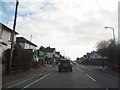
2
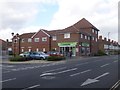
Bognor Regis, convenience store
Co-operative Food, on Hawthorn Road.
Image: © Mike Faherty
Taken: 18 Mar 2014
0.16 miles
3
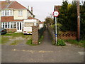
Twitten from Hawthorn Road
Public Footpath 3041 to Kenilworth Road.
Image: © Peter Holmes
Taken: 14 Apr 2012
0.18 miles
4
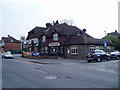
The Wheatsheaf, Hawthorn Road
Traditional styled pub in residential area built just before second world war.
Image: © Peter Holmes
Taken: 14 Apr 2012
0.19 miles
6
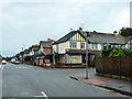
Magpies, Bognor Regis
A second-hand shop at the corner of Hawthorn Road and Linden Road. The window is shuttered, so presumably the shop is closed on a Saturday afternoon.
Image: © Robin Webster
Taken: 19 Oct 2013
0.20 miles
7
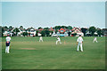
Bognor Regis Cricket Club, 2000
A touring side from Cambridge batted first. The man with the camera had opened the batting, scratted about for half an hour and then been lbw, as usual. Houses on Nyewood Lane form the backdrop.
Image: © John Sutton
Taken: Unknown
0.24 miles