IMAGES TAKEN NEAR TO
Link Way, BOGNOR REGIS, PO21 4QB
Introduction
This page details the photographs taken nearby to Link Way, PO21 4QB by members of the Geograph project.
The Geograph project started in 2005 with the aim of publishing, organising and preserving representative images for every square kilometre of Great Britain, Ireland and the Isle of Man.

There are currently over 7.5m images from over14,400 individuals and you can help contribute to the project by visiting https://www.geograph.org.uk
Image Map
Images are licensed for reuse under creativecommons.org/licenses/by-sa/2.0
Notes
- Clicking on the map will re-center to the selected point.
- The higher the marker number, the further away the image location is from the centre of the postcode.
Image Listing (8 Images Found)
Images are licensed for reuse under creativecommons.org/licenses/by-sa/2.0
Image
Details
Distance
1
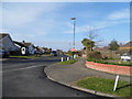
Cardinal's Drive at the junction of Link Way
Image: © David Howard
Taken: 15 Apr 2013
0.03 miles
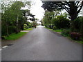
2
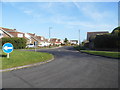
Viscount Drive from The Causeway, Pagham
Image: © David Howard
Taken: 15 Apr 2013
0.15 miles
3
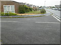
Looking westwards on The Causeway from the junction with Conway Drive
Image: © Shazz
Taken: 14 Aug 2015
0.17 miles
4
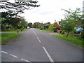
Apple Grove
Public footpath 113 to Pagham Road.
Image: © Peter Holmes
Taken: 12 May 2012
0.18 miles
6
Manor Way
Public footpath 113 to Pagham Road.
Image: © Peter Holmes
Taken: 12 May 2012
0.24 miles
7
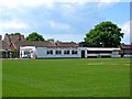
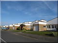
Pagham Football Club (2) - clubhouse, Nyetimber Lane
The club known locally as the Lions, was formed in 1903. They came to this ground in 1950. The clubhouse is home to the Pagham F.C. Social Club. Part of the building contains the dressing rooms.
Image
Image
Image: © P L Chadwick
Taken: 28 May 2010
0.25 miles
8
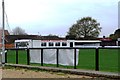
Clubhouse, Nyetimber Lane, Pagham Football Club
Image: © nick macneill
Taken: 25 Apr 2012
0.25 miles