IMAGES TAKEN NEAR TO
Coventry Close, BOGNOR REGIS, PO21 3RT
Introduction
This page details the photographs taken nearby to Coventry Close, PO21 3RT by members of the Geograph project.
The Geograph project started in 2005 with the aim of publishing, organising and preserving representative images for every square kilometre of Great Britain, Ireland and the Isle of Man.

There are currently over 7.5m images from over14,400 individuals and you can help contribute to the project by visiting https://www.geograph.org.uk
Image Map
Images are licensed for reuse under creativecommons.org/licenses/by-sa/2.0
Notes
- Clicking on the map will re-center to the selected point.
- The higher the marker number, the further away the image location is from the centre of the postcode.
Image Listing (17 Images Found)
Images are licensed for reuse under creativecommons.org/licenses/by-sa/2.0
Image
Details
Distance
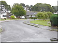
1
Looking into Wells Crescent from the eastern end
Image: © Shazz
Taken: 14 Aug 2015
0.07 miles
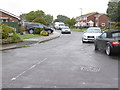
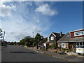
2
Looking west on Westminster Drive past Wells Crescent
Image: © Shazz
Taken: 14 Aug 2015
0.09 miles
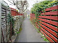
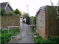
4
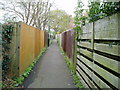
Path to Hewart's Lane
Public footpath 3033.
Image: © Peter Holmes
Taken: 14 Apr 2012
0.12 miles
7
Path approaching Ely Gardens
Public footpath 3033.
Image: © Peter Holmes
Taken: 14 Apr 2012
0.15 miles
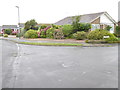
8
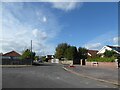
Junction of Sefton Avenue and Robins Drive
Image: © Basher Eyre
Taken: 8 Oct 2020
0.16 miles
9
Path from Hewart's Lane to Lower Bognor Road
Public footpath 3033.
Image: © Peter Holmes
Taken: 14 Apr 2012
0.18 miles
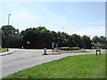
10
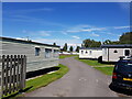
Copthorne Caravan Park, off Hewart's Lane, Rose Green
Image: © Jeff Gogarty
Taken: 9 Jul 2021
0.20 miles