IMAGES TAKEN NEAR TO
Wood Street, BOGNOR REGIS, PO21 2PJ
Introduction
This page details the photographs taken nearby to Wood Street, PO21 2PJ by members of the Geograph project.
The Geograph project started in 2005 with the aim of publishing, organising and preserving representative images for every square kilometre of Great Britain, Ireland and the Isle of Man.

There are currently over 7.5m images from over14,400 individuals and you can help contribute to the project by visiting https://www.geograph.org.uk
Image Map
Images are licensed for reuse under creativecommons.org/licenses/by-sa/2.0
Notes
- Clicking on the map will re-center to the selected point.
- The higher the marker number, the further away the image location is from the centre of the postcode.
Image Listing (157 Images Found)
Images are licensed for reuse under creativecommons.org/licenses/by-sa/2.0
Image
Details
Distance
4
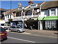
Old fashioned barber's shop, the village
Aldwick Road, Bognor Regis.
Image: © Jeff Gogarty
Taken: 8 Sep 2016
0.05 miles
5
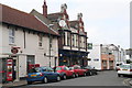
The Victoria Inn on the corner of Oxford Street
Image: © Chris
Taken: 15 Jun 2013
0.05 miles
6
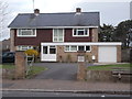
St Wilfrid's Vicarage - Victoria Drive
Image: © Betty Longbottom
Taken: 13 Apr 2015
0.06 miles
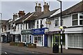
9
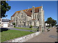
St Wilfrid's, Victoria Drive, Bognor Regis
A high Anglican Church serving as the main parish church for Bognor.
Image: © Jeff Gogarty
Taken: 8 Sep 2016
0.06 miles