IMAGES TAKEN NEAR TO
Clarence Road, BOGNOR REGIS, PO21 1JT
Introduction
This page details the photographs taken nearby to Clarence Road, PO21 1JT by members of the Geograph project.
The Geograph project started in 2005 with the aim of publishing, organising and preserving representative images for every square kilometre of Great Britain, Ireland and the Isle of Man.

There are currently over 7.5m images from over14,400 individuals and you can help contribute to the project by visiting https://www.geograph.org.uk
Image Map
Images are licensed for reuse under creativecommons.org/licenses/by-sa/2.0
Notes
- Clicking on the map will re-center to the selected point.
- The higher the marker number, the further away the image location is from the centre of the postcode.
Image Listing (744 Images Found)
Images are licensed for reuse under creativecommons.org/licenses/by-sa/2.0
Image
Details
Distance
1
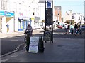
Cafe Sign - Bognor
Quite an amusing sign in the High St at Bognor. It reads, " Probably the best breakfast in the universe. (except Grimsby)"
No false modesty here.
Image: © Colin Babb
Taken: 9 Oct 2008
0.01 miles


6
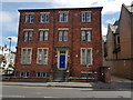
Glenlogie House, Clarence Road, Bognor Regis
Includes a homeless shelter attached to Catholic Church of Our Lady of Sorrows.
Image: © Jeff Gogarty
Taken: 18 Jul 2020
0.02 miles
8
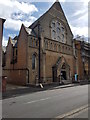
Catholic Church of Our Lady of Sorrows, Bognor Regis
Image: © Jeff Gogarty
Taken: 18 Jul 2020
0.02 miles