IMAGES TAKEN NEAR TO
Field Road, CHICHESTER, PO20 8NN
Introduction
This page details the photographs taken nearby to Field Road, PO20 8NN by members of the Geograph project.
The Geograph project started in 2005 with the aim of publishing, organising and preserving representative images for every square kilometre of Great Britain, Ireland and the Isle of Man.

There are currently over 7.5m images from over14,400 individuals and you can help contribute to the project by visiting https://www.geograph.org.uk
Image Map
Images are licensed for reuse under creativecommons.org/licenses/by-sa/2.0
Notes
- Clicking on the map will re-center to the selected point.
- The higher the marker number, the further away the image location is from the centre of the postcode.
Image Listing (16 Images Found)
Images are licensed for reuse under creativecommons.org/licenses/by-sa/2.0
Image
Details
Distance
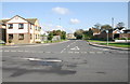
1
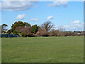
Downview playing field, East Wittering
Image: © Robin Webster
Taken: 1 Mar 2014
0.11 miles
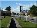
2
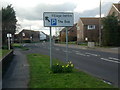
B2179 at East Wittering
Approaching the village centre from Bracklesham
Image: © Rosie Simons
Taken: 9 Mar 2008
0.15 miles
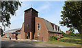
4

St Anne, East Wittering - Stained glass window
Image: © John Salmon
Taken: 12 Jul 2014
0.17 miles
5

St Anne, East Wittering - Stained glass window
Image: © John Salmon
Taken: 12 Jul 2014
0.17 miles

7
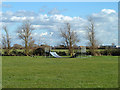
Skateboard facility, East Wittering
Called Downsview Skate Park, although the apparatus occupies just a small area in a large field.
Image: © Robin Webster
Taken: 1 Mar 2014
0.18 miles
10
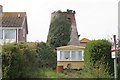
East Wittering
A very unhappy windmill off Mill Gardens. Most of this square is residential.
Image: © Brendan and Ruth McCartney
Taken: 22 Apr 2005
0.22 miles