IMAGES TAKEN NEAR TO
Coney Road, CHICHESTER, PO20 8DA
Introduction
This page details the photographs taken nearby to Coney Road, PO20 8DA by members of the Geograph project.
The Geograph project started in 2005 with the aim of publishing, organising and preserving representative images for every square kilometre of Great Britain, Ireland and the Isle of Man.

There are currently over 7.5m images from over14,400 individuals and you can help contribute to the project by visiting https://www.geograph.org.uk
Image Map
Images are licensed for reuse under creativecommons.org/licenses/by-sa/2.0
Notes
- Clicking on the map will re-center to the selected point.
- The higher the marker number, the further away the image location is from the centre of the postcode.
Image Listing (23 Images Found)
Images are licensed for reuse under creativecommons.org/licenses/by-sa/2.0
Image
Details
Distance
1
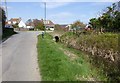
Culvert by Longlands Road, East Wittering
The culvert runs under a small close called Coney Six.
Image: © Dave Spicer
Taken: 30 Apr 2013
0.07 miles
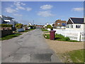
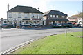
3
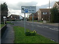
B2179 at East Wittering
Approaching the village centre from Bracklesham
Image: © Rosie Simons
Taken: 9 Mar 2008
0.13 miles
4
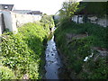
Stream running between houses on Charlmead
Image: © Dave Spicer
Taken: 30 Apr 2013
0.15 miles
5
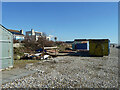
Beach hut storm damage, East Wittering, 2014
Image: © Robin Webster
Taken: 1 Mar 2014
0.17 miles
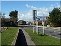
8

East Wittering Fire Station
East Wittering Fire Station, Oakfield Road, East Wittering, West Sussex
Image: © Kevin Hale
Taken: 7 May 2007
0.20 miles
9
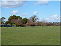
Downview playing field, East Wittering
Image: © Robin Webster
Taken: 1 Mar 2014
0.20 miles