IMAGES TAKEN NEAR TO
Sidlesham Lane, CHICHESTER, PO20 7QL
Introduction
This page details the photographs taken nearby to Sidlesham Lane, PO20 7QL by members of the Geograph project.
The Geograph project started in 2005 with the aim of publishing, organising and preserving representative images for every square kilometre of Great Britain, Ireland and the Isle of Man.

There are currently over 7.5m images from over14,400 individuals and you can help contribute to the project by visiting https://www.geograph.org.uk
Image Map
Images are licensed for reuse under creativecommons.org/licenses/by-sa/2.0
Notes
- Clicking on the map will re-center to the selected point.
- The higher the marker number, the further away the image location is from the centre of the postcode.
Image Listing (18 Images Found)
Images are licensed for reuse under creativecommons.org/licenses/by-sa/2.0
Image
Details
Distance
1
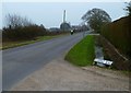
Sign for caravan site at Woodhorn Farm
A Caravan Club certificated site on the edge of Birdham
Image: © David Smith
Taken: 3 Jul 2015
0.04 miles
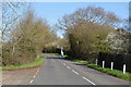
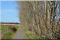
2
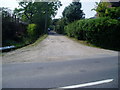
Looking south on Sidlesham Lane from footpath junction
Image: © Shazz
Taken: 2 Mar 2012
0.05 miles
3
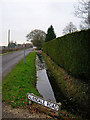
Drainage ditch, Sidlesham Lane
One of many in this area. This view looks south from the junction with Alandale Road.
Image: © Simon Carey
Taken: 21 Dec 2005
0.06 miles
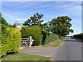
4
The east end of Alandale Road
The road sign has suffered injury since the earlier submission at http://www.geograph.org.uk/photo/93923. Also pipes have been added above the drainage channel.
Image: © Shazz
Taken: 2 Mar 2012
0.11 miles
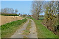
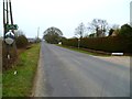
5
Alandale Road
Public footpath 2821 on potholed road.
Image: © Peter Holmes
Taken: 24 May 2012
0.12 miles