IMAGES TAKEN NEAR TO
Birdham Road, CHICHESTER, PO20 7BX
Introduction
This page details the photographs taken nearby to Birdham Road, PO20 7BX by members of the Geograph project.
The Geograph project started in 2005 with the aim of publishing, organising and preserving representative images for every square kilometre of Great Britain, Ireland and the Isle of Man.

There are currently over 7.5m images from over14,400 individuals and you can help contribute to the project by visiting https://www.geograph.org.uk
Image Map
Images are licensed for reuse under creativecommons.org/licenses/by-sa/2.0
Notes
- Clicking on the map will re-center to the selected point.
- The higher the marker number, the further away the image location is from the centre of the postcode.
Image Listing (12 Images Found)
Images are licensed for reuse under creativecommons.org/licenses/by-sa/2.0
Image
Details
Distance
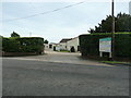
2
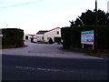
Entrance to Birdham Business Park
The road is the A286.
Image: © Shazz
Taken: 15 Jan 2012
0.05 miles
4
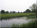
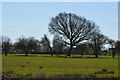
Looking across Chichester Ship Canal to Coombers Barn Farm
Image: © Basher Eyre
Taken: 5 May 2008
0.11 miles
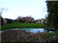
5
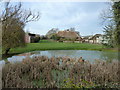
Pond and thatched roof at Manhoodend Farm
Image: © Dave Spicer
Taken: 26 Jan 2013
0.12 miles
6
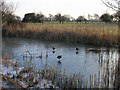
Ducks on the frozen Chichester Canal
Looking south east from the footpath next to Chichester Marina.
Image: © Simon Carey
Taken: 29 Dec 2005
0.21 miles
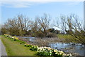
9
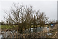
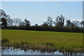
Chichester Ship Canal
The disused Chichester Ship Canal with a houseboat on the right.
Image: © Ian Capper
Taken: 22 Feb 2015
0.24 miles