IMAGES TAKEN NEAR TO
Lifeboat Way, CHICHESTER, PO20 0TT
Introduction
This page details the photographs taken nearby to Lifeboat Way, PO20 0TT by members of the Geograph project.
The Geograph project started in 2005 with the aim of publishing, organising and preserving representative images for every square kilometre of Great Britain, Ireland and the Isle of Man.

There are currently over 7.5m images from over14,400 individuals and you can help contribute to the project by visiting https://www.geograph.org.uk
Image Map
Images are licensed for reuse under creativecommons.org/licenses/by-sa/2.0
Notes
- Clicking on the map will re-center to the selected point.
- The higher the marker number, the further away the image location is from the centre of the postcode.
Image Listing (28 Images Found)
Images are licensed for reuse under creativecommons.org/licenses/by-sa/2.0
Image
Details
Distance

2
Memorial tablet by Selsey beach
The tablet is in memory of those who died when a bomb fell on a holiday camp being used by London evacuees in 1940 Image]
Image: © David Smith
Taken: 24 Jun 2013
0.12 miles
3
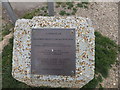
Memorial tablet to wartime bombing deaths
The tablet is in memory of four London evacuees who died when Broadreeds Holiday Camp was bombed in 1940
Image: © David Smith
Taken: 24 Jun 2013
0.12 miles
4
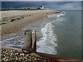
Beach at Selsey Bill
Ian Nairn writing about Selsey in the Buildings of England says "Somehow very English, in the inconsequential way it has muddled through with its topography. Like Dunwich, it was originally an important town in Saxon England which has been affected by coastal erosion; like Dunwich, it still looks as though half of it is missing. It was the see of a Saxon bishop. The see moved to Chichester only in 1075. Since Domesday about half a mile has been eroded from Selsey Bill, and therefore the legend of a 'cathedral under the sea' is almost certainly true.
The village developed about half a mile inland from the Bill, with its church at Church Norton. In the early 19th century it began to expand, moved the nave arcades into a new church in the village, and left the chancel by itself in the old churchyard. Then the 20th century came... today's Selsey is one main street .. which runs straight on to the sea and stops abruptly without pier or esplanade."
This view is from a point immediately east of Selsey Bill where the coastline swings back towards the north-east. The thunderstorm seen ahead stayed further inland.
Image: © Marathon
Taken: 3 Sep 2015
0.16 miles
6
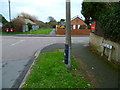
The crossing of Grafton Road by Grove Road in Selsey
Grove Road continues as a footpath to the east.
Image: © Shazz
Taken: 28 Jan 2012
0.17 miles
7
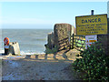
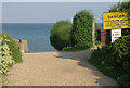
Oval Lane beach access
A coastal footpath runs left from here, but has to come inland to get to the right. This is because the property on the right extends right out to a defended high tide line, so it is either impossible or foolhardy to attempt to pass along the beach at higher tide levels.
Image: © Robin Webster
Taken: 20 Feb 2014
0.18 miles
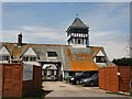
8
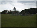
Recreation field and Bill House, Selsey Bill
The recreation ground is close to the site of a gibbet used to display the bones of smugglers in the 18th century. Bill House is listed, grade II, and was built in 1907 by M H Baillie Scott in the Arts and Craft style. The tower was used by the Coastguard
Image: © David Smith
Taken: 24 Jun 2013
0.19 miles
9
Oval Lane, Selsey
Oval Lane peters out into this track down to the sea close to Selsey Bill.
Image: © Stephen McKay
Taken: 30 Apr 2011
0.19 miles
10
The Bill House, Selsey
Residential care Home in Grafton Road http://www.carehome.co.uk/carehome.cfm/searchazref/10001070BILA
Image: © Paul Gillett
Taken: 19 May 2012
0.20 miles