IMAGES TAKEN NEAR TO
Park Lane, CHICHESTER, PO20 0HF
Introduction
This page details the photographs taken nearby to Park Lane, PO20 0HF by members of the Geograph project.
The Geograph project started in 2005 with the aim of publishing, organising and preserving representative images for every square kilometre of Great Britain, Ireland and the Isle of Man.

There are currently over 7.5m images from over14,400 individuals and you can help contribute to the project by visiting https://www.geograph.org.uk
Image Map
Images are licensed for reuse under creativecommons.org/licenses/by-sa/2.0
Notes
- Clicking on the map will re-center to the selected point.
- The higher the marker number, the further away the image location is from the centre of the postcode.
Image Listing (6 Images Found)
Images are licensed for reuse under creativecommons.org/licenses/by-sa/2.0
Image
Details
Distance
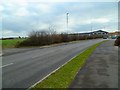
1
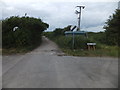
Footpath along track to Park Farm, Selsey
I am not sure why the farm track has speed derestriction signs at the end.
Image: © David Smith
Taken: 24 Jun 2013
0.11 miles
2
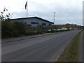
Oceanair factory and offices
Modern factory building on the edge of Selsey
Image: © David Smith
Taken: 24 Jun 2013
0.21 miles
3
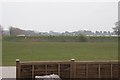
Selsey
Looking east towards The Grange from the entrance to the large Nature's Way Foods establishment, almost mid-square.
Image: © Brendan and Ruth McCartney
Taken: 22 Apr 2005
0.22 miles
5
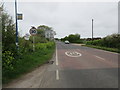
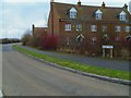
Approaching Selsey on Chichester Road (B2145)
Bus stop for Stagecoach gold service 51 from Chichester to Selsey.
Image: © Peter Holmes
Taken: 2 May 2015
0.23 miles